 Filter: Categories of Wisconsin Historical Images
Filter: Subject of Cities and towns
Filter: Community of Prairie du Chien
Filter: Categories of Wisconsin Historical Images
Filter: Subject of Cities and towns
Filter: Community of Prairie du Chien

| Date: | 1880 |
|---|---|
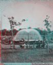
| Description: | Stereograph of the Artesian Well near the intersection of Wisconsin and Minnesota (later renamed Wacouta) Streets. The following is printed on the back of ... |
| Date: | 1880 |
|---|---|
| Description: | Stereograph of the Artesian Well near the intersection of Wisconsin and Minnesota (later renamed Wacouta) Streets. The following is printed on the backside... |

| Date: | 1870 |
|---|---|
| Description: | Stereograph of John Lawler's pile-pontoon railway bridge over the Mississippi River. |
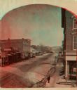
| Date: | 1880 |
|---|---|
| Description: | Stereograph looking northeast from Case's Block. |

| Date: | 1820 |
|---|---|
| Description: | This map displays the plan for claiming various settlement zones in the Prairie des Chiens area in 1820. It shows Fort Crawford and 87 confirmed and unconf... |

| Date: | 1830 |
|---|---|
| Description: | This early 19th century manuscript map of Prairie du Chien, Wisconsin, shows sections, landownership and acreages, roads, and ferries in the towns of Bridg... |

| Date: | |
|---|---|
| Description: | "Section of New Prairie du Chien Marquette $1,000,000 Suspension Bridge. Total length 3729 feet. Only suspension bridge on the Mississippi River. Open for ... |

| Date: | |
|---|---|
| Description: | An outdoor family portrait with a golf theme. Several members are sitting on a bench and the lawn, with a large house in the background. There are two dogs... |
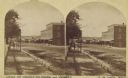
| Date: | 1875 |
|---|---|
| Description: | Stereograph view of Black Hawk Avenue. |

| Date: | 1882 |
|---|---|
| Description: | This map is ink on cardboard and shows the location of military forts over the course of years. Also shown are points of interest, streets, the Mississippi... |

| Date: | 1864 |
|---|---|
| Description: | This map is ink, pencil, and color on paper and shows numbered lots and labeled streets. The bottom margin of the map reads: "Recorded in the Registry of d... |

| Date: | 01 15 1929 |
|---|---|
| Description: | Intended for tourists, this brochure, titled: "Winneshiek World’s Famous Wild Life Refuge Historic Fort Crawford and Picturesque Prairie du Chien," feature... |

| Date: | 1950 |
|---|---|
| Description: | Intended for tourists, this brochure features two maps with tourists sites along the Mississippi River. One map shows roads and populated places along the ... |

| Date: | 1976 |
|---|---|
| Description: | This map includes an index of streets, government and historic buildings, hospitals, schools, places of recreation, churches, cemeteries, and other miscell... |

| Date: | 1800 |
|---|---|
| Description: | This map is ink and watercolor on paper and shows the main channel and sand bars in the Mississippi River between villages. |

| Date: | 1830 |
|---|---|
| Description: | This map is ink, color, and pencil on paper and shows streets, farm lots, and a church. Handwritten notes are at the bottom of the map and are very light. |

| Date: | 1838 |
|---|---|
| Description: | This map is a development plat that shows street names, numbered blocks and lots, and small farm lot owners. Included on the right of the map is a large am... |

| Date: | 06 1853 |
|---|---|
| Description: | This map is ink, pencil, and color on paper and shows lot and block numbers and dimensions, sold lots, streets, and the Mississippi River. Some lots are co... |

| Date: | 1856 |
|---|---|
| Description: | This map shows lot and block numbers, streets, the Mississippi River, Fort Crawford, depot ground, and a graveyard. An old fort location is outlined in red... |

| Date: | 12 05 1854 |
|---|---|
| Description: | This plat map shows landowners, the Mississippi River, the Marais de St. Friole, and an old fort. The left margin reads: "Part of the Main Village of Prair... |
If you didn't find the material you searched for, our Library Reference Staff can help.
Call our reference desk at 608-264-6535 or email us at: