 Filter: Categories of Wisconsin Historical Images
Filter: Subject of Civil War, 1861-1865
Filter: Subject of church buildings
Filter: Categories of Wisconsin Historical Images
Filter: Subject of Civil War, 1861-1865
Filter: Subject of church buildings
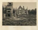
| Date: | 1890 |
|---|---|
| Description: | Site of the Battle to Antietam, The Dunker Church. A group of men stand among trees on the left. Horse-drawn carriages are under trees on the right. |
| Date: | 11 08 1906 |
|---|---|
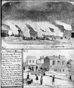
| Description: | Two Civil War watercolor drawings by John Gaddis, Company E, 12th Wisconsin Volunteer Infantry, showing the regiment in bivouac, and later their headquarte... |
| Date: | 06 1862 |
|---|---|
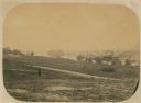
| Description: | The 7th Wisconsin Volunteer Infantry Regiment camp outside of Fredericksburg on the east side of the Rappahannock. Fredericksburg and a pontoon bridge lea... |

| Date: | 1910 |
|---|---|
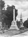
| Description: | View of monument from the sidewalk, with a church behind. Several trees and lampposts are visible. |

| Date: | 1935 |
|---|---|
| Description: | The Court of Honor, Wisconsin Avenue. The statue, "The Victorious Charge," is in the center, with a church behind. On the left are more buildings going int... |

| Date: | |
|---|---|
| Description: | View of Harper's Ferry, showing the pontoon bridge and bridge (extreme left) which was destroyed in 1861. |
| Date: | 1900 |
|---|---|
| Description: | A view of a The Soldiers' Monument, erected on November 1, 1865 by Dan Rice, a famous circus man. The memorial is said to be the first built honoring the s... |
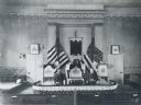
| Date: | 05 25 1901 |
|---|---|
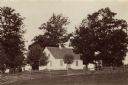
| Description: | Grand Army of the Republic, Jairus Richardson, Post No. 12 in Sheboygan Falls, Wisconsin, meeting at the Methodist Church. From left to right are: Charles ... |
| Date: | 1865 |
|---|---|
| Description: | The ruins of Charleston after General Sherman's men burned the town near the end of the Civil War. A man, smoking a pipe, and a boy sit on the shoreline of... |
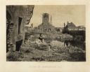
| Date: | 1866 |
|---|---|
| Description: | The ruins of a church in Columbia after General Sherman's men burned the town near the end of the Civil War. Plate 54 |
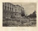
| Date: | 1866 |
|---|---|
| Description: | Construction on the new capitol building. A church is behind the construction. Plate 52 |

| Date: | |
|---|---|
| Description: | This detailed map shows fortifications, headquarters, location and dates of battles, street outline of Atlanta, roads, railroads, vegetation, drainage, rel... |
If you didn't find the material you searched for, our Library Reference Staff can help.
Call our reference desk at 608-264-6535 or email us at: