 Filter: Categories of Wisconsin Historical Images
Filter: Subject of Civil War, 1861-1865
Filter: Subject of lakes
Filter: Categories of Wisconsin Historical Images
Filter: Subject of Civil War, 1861-1865
Filter: Subject of lakes
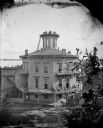
| Date: | 1877 |
|---|---|
| Description: | This building, on an entire block of Spaight and Brearly Streets with Lake Monona, was originally the governor's mansion for Leonard J. Farwell. The Farwel... |
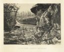
| Date: | 1866 |
|---|---|
| Description: | Cliffs along Lu-la Lake. A waterfall is in the background. Plate 15 |

| Date: | 1862 |
|---|---|
| Description: | This map of the southeastern United States shows cities and towns, rail lines, and geographic features such as rivers, mountains, lakes, and swamps. |

| Date: | 1864 |
|---|---|
| Description: | This colored map of the southern and eastern states shows locations of battles and skirmishes from 1861 through May 1864 with red dots or red underlining o... |
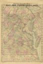
| Date: | 1865 |
|---|---|
| Description: | A general map of eastern Virginia, Maryland, Delaware, southern Pennsylvania, and northern North Carolina. |
If you didn't find the material you searched for, our Library Reference Staff can help.
Call our reference desk at 608-264-6535 or email us at: