 Filter: Categories of Wisconsin Historical Images
Filter: Subject of Civil War, 1861-1865
Filter: Subject of land
Filter: Categories of Wisconsin Historical Images
Filter: Subject of Civil War, 1861-1865
Filter: Subject of land
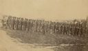
| Date: | 1862 |
|---|---|
| Description: | Company I, 7th Regiment Wisconsin Volunteer Infantry, at Upton's Hill near Germantown, Virginia. The 7th was one of three Wisconsin regiments that was part... |

| Date: | 1862 |
|---|---|
| Description: | This map of eastern Virginia and Maryland shows rivers, roads and railroads from Hagerstown, Maryland, south to Suffolk, Virginia, and west to Staunton, Vi... |

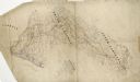
| Date: | 1862 |
|---|---|
| Description: | The second in a series of three maps of the Virginia Peninsula. This map details the area from Williamsburg north to West Point. |

| Date: | 1862 |
|---|---|
| Description: | The third in a series of three maps of the Virginia Peninsula. This map details the area from Harrison's Landing west to Richmond and shows troop positions... |

| Date: | 1863 |
|---|---|
| Description: | This map is a hand-colored, pen and ink, drawing by Ole R. Dahl of Co. B, 15 Wisconsin Infantry shows the battlefield at Stones River, depicting roads, str... |
| Date: | 1864 |
|---|---|
| Description: | This pen and ink tracing illustrates the route traveled by Sherman's troops through Georgia, South Carolina, and North Carolina in the winter and spring of... |

| Date: | 1862 |
|---|---|
| Description: | This map consists of four separate panels. The first illustrates the battlefield at Cedar Mountain on Aug. 9, 1862, where the 3rd Wisconsin Infantry fought... |
If you didn't find the material you searched for, our Library Reference Staff can help.
Call our reference desk at 608-264-6535 or email us at: