 Filter: Categories of Wisconsin Historical Images
Filter: Subject of Civil War, 1861-1865
Filter: Subject of maps
Filter: Categories of Wisconsin Historical Images
Filter: Subject of Civil War, 1861-1865
Filter: Subject of maps
| Date: | |
|---|---|
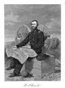
| Description: | An engraving from a photograph of Ulysses S. Grant wearing a military uniform. He is seated in front of a cannon with a map unfolded in his lap, and cannon... |

| Date: | |
|---|---|
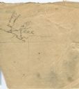
| Description: | A very vague sketch of a map of North Racine, Wisconsin. |
| Date: | |
|---|---|
| Description: | A simple sketch of a section of Arkansas, showing the Arkansas River, White River and Helena, Arkansas. |

| Date: | 08 10 1862 |
|---|---|
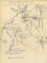
| Description: | A hand-drawn map of the Battle of Wilson's Creek, Springfield, Missouri. Other notes and locations include: "Lyon was killed instantly while heading his tr... |

| Date: | |
|---|---|
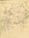
| Description: | A hand-drawn map of the state of Missouri with a separate drawing of a map showing Forts Henry and Donelson. The Missouri map includes Jefferson City and s... |
| Date: | 04 06 1862 |
|---|---|
| Description: | A hand-drawn map of the Battle of Shiloh, Pittsburg Landing, Tennessee. Additional Notes include "Reserve Artillery," "Hospital," "Owl Creek," and "Snake C... |
| Date: | |
|---|---|
| Description: | A hand-drawn map of Tennessee and surrounding states. Some cities located include: St. Louis, Louisville, Cinncinati, Nashville, Murfreesboro, Knoxville, T... |

| Date: | 1862 |
|---|---|
| Description: | Birds-eye view of a Wisconsin Civil War regiment on parade in Fond du Lac, as drawn by Louis Kurz from the Marr Street Methodist Church. The regiment canno... |
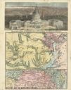
| Date: | 08 1861 |
|---|---|
| Description: | Large-format, illustrated stationery purchased by Rudolph Fine, a member of the 6th Wisconsin Infantry in August, 1861, showing the Capitol (in actuality, ... |

| Date: | |
|---|---|
| Description: | A tinted tintype of a Civil War soldier posing with an officer's sword in front of an elaborately painted studio backdrop depicting a tent, an American fla... |
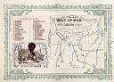
| Date: | 1860 |
|---|---|
| Description: | African American man, left, map depicting Maryland, Virginia, Delaware and the border of Pennsylvania, right. Key of "DIRECTIONS" in upper right corner. At... |
If you didn't find the material you searched for, our Library Reference Staff can help.
Call our reference desk at 608-264-6535 or email us at: