 Filter: Categories of Wisconsin Historical Images
Filter: Subject of Coasts
Filter: Year of 1700-1799
Filter: Year of 1750-1759
Filter: Categories of Wisconsin Historical Images
Filter: Subject of Coasts
Filter: Year of 1700-1799
Filter: Year of 1750-1759

| Date: | 1755 |
|---|---|
| Description: | Map of the northeastern portion of America and Canada, east of the Hudson River and south from Labrador. It names regions, colonies, cities, numerous forts... |

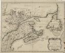
| Date: | 1759 |
|---|---|
| Description: | Map of north eastern Canada and parts of New England, showing settlements, cities, portages, Native American land, mountains, lakes, and rivers. The unusua... |
| Date: | 1755 |
|---|---|
| Description: | Bellin's landmark map of eastern Canada and part of northeast America extending from Newfoundland to the borders of Lake Ontario and south to Cape Cod. The... |

| Date: | 1752 |
|---|---|
| Description: | Map of the the coast line of Louisiana, focusing on the Mississippi, the Arkansas, the Red, the Osage, and the Missouri River. An inset map along the righ... |

| Date: | 1759 |
|---|---|
| Description: | Map of New Orleans at the start of the French & Indian War, including two inset maps entitled "The Course of the Mississipi River from Bayagoulas to the Se... |
If you didn't find the material you searched for, our Library Reference Staff can help.
Call our reference desk at 608-264-6535 or email us at: