 Filter: Categories of Wisconsin Historical Images
Filter: Subject of Coasts
Filter: Categories of Wisconsin Historical Images
Filter: Subject of Coasts

| Date: | |
|---|---|
| Description: | View along shoreline toward a lighthouse and homes standing on Rocky Point. There are several boats anchored at the shore and in the water. |
| Date: | |
|---|---|
| Description: | Homes stand along the coast near cliffs on Block Island. |
| Date: | |
|---|---|
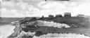
| Description: | View from beach dunes looking north. View features many plants on sand dunes in the forefront, and people on a sandy beach, many dwellings, and a flag in t... |

| Date: | |
|---|---|
| Description: | Elevated view of Bermuda shoreline. Several dwellings stand on top of the island and people swim in the ocean on the beaches below. |

| Date: | |
|---|---|
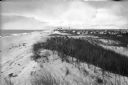
| Description: | People stand and sit on a driftwood-cluttered beach. Several people swim in the ocean. Caption reads: "Scene on the Beach. Long Beach. Wash." |
| Date: | 1945 |
|---|---|
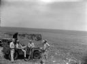
| Description: | Leota Kelly, directer of the Pacific Athletic Club, division of the Red Cross, and colleagues, at the site of the new Red Cross Club in Tinian near a cliff... |
| Date: | 1945 |
|---|---|
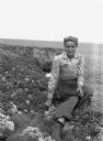
| Description: | Leota Kelly, director of the Red Cross's Pacific Athletic Club, posing for a picture by the shore in Tinian at the site of the new Red Cross Club. Kelly is... |

| Date: | 1937 |
|---|---|
| Description: | A pictorial, hydrographic map shows sailing courses, historical and contemporary coastal attractions, roads, and the contour depths of Green Lake, Wisconsi... |

| Date: | 1899 |
|---|---|
| Description: | Topographical map showing ridges, water courses, boundary lines, and trails and roads near the Stanley McCormick's Riven Rock estate in El Montecito, Santa... |

| Date: | 1899 |
|---|---|
| Description: | A map showing the shoreline of a portion of El Montecito, Santa Barbara County, California. The map shows properties along the Pacific Ocean, and may have ... |

| Date: | 1911 |
|---|---|
| Description: | This 1911 map of the geology of northern Wisconsin between Superior and Hurley was published by the Wisconsin Geological and Natural History Survey in Fred... |

| Date: | 1902 |
|---|---|
| Description: | Map of Southern Norway with text in Norwegian. The scale of the map is 1:500000. |

| Date: | 1902 |
|---|---|
| Description: | Map of Southern Norway with text in Norwegian. Scale of map 1:500000. |

| Date: | 1918 |
|---|---|
| Description: | Map showing Aleppo, Zor, Syria, Lebanon, Beirut, Jerusalem, with an inset map of the Sinai Peninsula and Egyptian frontier. Also shows the locations of rai... |

| Date: | 1990 |
|---|---|
| Description: | Color photo of an International school bus driven along a coastal road. In the foreground is a split-rail fence and lawn. The photograph was probably taken... |

| Date: | 1967 |
|---|---|
| Description: | Black and white photographic greeting card. View down beach towards couple hugging while standing in the sand. The word "love" is centered at the top. |
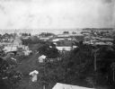
| Date: | 1902 |
|---|---|
| Description: | Elevated view of the city of Port Limon, Costa Rica with the Caribbean Sea in the background. Trees grow amongst the many commercial and residential buildi... |

| Date: | |
|---|---|
| Description: | Letterhead of Johnson & Melaas, merchant tailors and cloth dealers, "Buyers of wool and Wisconsin leaf tobacco," with an engraving of a waterfront view of ... |

| Date: | 1951 |
|---|---|
| Description: | This map is a survey of Lake Michigan and the section of Milwaukee that borders the lake. Map of land includes major streets, and landmarks near water. Rel... |

| Date: | |
|---|---|
| Description: | Three-quarter view from front of passenger side of Scout parked on beach. The Scout has a windshield and roll bars in place, but no doors. The ocean is in ... |
If you didn't find the material you searched for, our Library Reference Staff can help.
Call our reference desk at 608-264-6535 or email us at: