 Filter: Categories of Wisconsin Historical Images
Filter: Subject of Dams
Filter: County of Juneau
Filter: Categories of Wisconsin Historical Images
Filter: Subject of Dams
Filter: County of Juneau
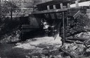
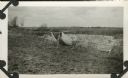
| Date: | 1908 |
|---|---|
| Description: | View from shoreline toward the lower part of a dam. Caption reads: "Dam in Elroy, Wis." |

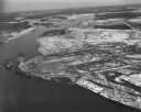
| Date: | 1950 |
|---|---|
| Description: | Aerial view of the Highway 21 bridge and Petenwell Dam on the Wisconsin River. |

| Date: | 1926 |
|---|---|
| Description: | This hand-colored blueprint map shows landowners in part of T15N, R5E in Juneau County. North is oriented to the right. |
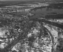
| Date: | 04 16 1949 |
|---|---|
| Description: | Aerial view of Necedah, Wisconsin, and Petenwell Lake behind Petenwell Dam on the Wisconsin River. |
| Date: | 04 16 1949 |
|---|---|
| Description: | Aerial view of Castle Rock Dam on the Wisconsin River near Mauston, Wisconsin. |
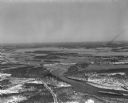
| Date: | 04 16 1949 |
|---|---|
| Description: | Aerial view of Petenwell Dam and dike on Wisconsin River twenty miles north of Necedah, Wisconsin showing the early formation of Lake Petenwell. |
| Date: | |
|---|---|
| Description: | The Civilian Conservation Corps dam built at Camp Petenwell near Necedah. |
If you didn't find the material you searched for, our Library Reference Staff can help.
Call our reference desk at 608-264-6535 or email us at: