 Filter: Categories of Wisconsin Historical Images
Filter: Subject of Deserts
Filter: Creator Name of Unknown
Filter: Subject of transportation
Filter: Categories of Wisconsin Historical Images
Filter: Subject of Deserts
Filter: Creator Name of Unknown
Filter: Subject of transportation
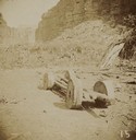
| Date: | 09 1897 |
|---|---|
| Description: | A Yava-supai [Havasupai] wagon at Cataract Canyon. |
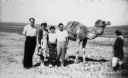
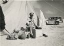
| Date: | 1955 |
|---|---|
| Description: | Eugene and Magda Herzberger (at left) with friends in the Negev region of Israel. They pose near a camel held on a tether by a man, possibly of Bedouin des... |
| Date: | |
|---|---|
| Description: | Elevated view of a mountain road in a desert landscape near Holbrook. |
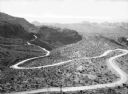
| Date: | |
|---|---|
| Description: | Elevated view of an old trail winding through a desert landscape with mountains in the background in the vicinity of Oatman. |
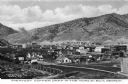
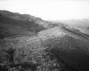
| Date: | |
|---|---|
| Description: | Elevated view of a copper mining camp with desert hills in the background. Caption reads: "Greatest Copper Camp in the World, Ely, Nevada." |
| Date: | 07 1941 |
|---|---|
| Description: | This portrait of CBS reporter Cecil Brown, then based in Rome, was taken during his tour of North Africa. It was later used as the cover illustration for h... |
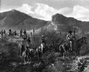
| Date: | |
|---|---|
| Description: | Guests at the Cambelback Inn ride horses along a mountain pass. The trail is surrounded by foliage and cacti. |
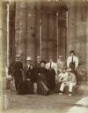
| Date: | 1896 |
|---|---|
| Description: | Group portrait including Violet Lee Dousman (back row, 4th from left) and her fellow travelers on a trip to Egypt. |
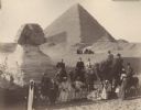
| Date: | 1896 |
|---|---|
| Description: | A group portrait of Violet Lee Dousman (back row, 3rd from left) and her fellow travelers, guides and Egyptians on a trip to Giza, Egypt. Five people are r... |

| Date: | 1920 |
|---|---|
| Description: | This blueprint map covers the boundary area between Lake Superior and the Lac Vieux Desert. The map reads: "Land lines, streams, lakes, railroads, cities a... |
If you didn't find the material you searched for, our Library Reference Staff can help.
Call our reference desk at 608-264-6535 or email us at: