 Filter: Categories of Wisconsin Historical Images
Filter: Subject of Deserts
Filter: Creator Name of Unknown
Filter: Categories of Wisconsin Historical Images
Filter: Subject of Deserts
Filter: Creator Name of Unknown
| Date: | |
|---|---|
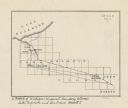
| Description: | This map shows the Michigan-Wisconsin boundary in Iron, Vilas, and Forest counties, Wisconsin, and Gogebic and Iron counties, Michigan. The Montreal River... |
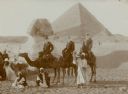
| Date: | 01 1909 |
|---|---|
| Description: | Three men in western dress riding camels pose with their Egyptian guides in front of the Sphinx at the Giza necropolis, with the Cheops pyramid in the back... |
| Date: | |
|---|---|
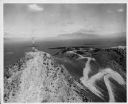
| Description: | Aerial view of two radio and television transmitters atop a butte in the Arco-Snake River desert. |

| Date: | 1920 |
|---|---|
| Description: | This blueprint map covers the boundary area between Lake Superior and the Lac Vieux Desert. The map reads: "Land lines, streams, lakes, railroads, cities a... |
If you didn't find the material you searched for, our Library Reference Staff can help.
Call our reference desk at 608-264-6535 or email us at: