 Filter: Categories of Wisconsin Historical Images
Filter: Subject of Dwellings
Filter: Subject of architecture
Filter: Subject of bridges
Filter: Categories of Wisconsin Historical Images
Filter: Subject of Dwellings
Filter: Subject of architecture
Filter: Subject of bridges

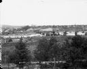
| Date: | 1905 |
|---|---|
| Description: | Elevated view of Soldiers' Grove with a bridge in the foreground. |
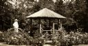
| Date: | 1917 |
|---|---|
| Description: | Log-constructed gazebo and person on bridge in rose garden. |
| Date: | |
|---|---|
| Description: | Elevated view from south side of the Chippewa River, with a bridge crossing it and buildings on both sides of the river. A bluff rises on the far side of t... |
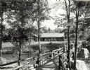
| Date: | 1940 |
|---|---|
| Description: | People on a rustic bridge over river at Copper Falls State Park. A long log building is in the background on the other side of the river. |
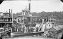
| Date: | |
|---|---|
| Description: | Steamboat Alexander Mitchell with passengers posed standing. Chairs are piled on shore at right. Edge of steamboat Dell Queen at left. Bridge... |
| Date: | 1900 |
|---|---|
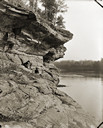
| Description: | View along rockface shoreline towards a woman and two children sitting on Angel Rock. Along a cliff along the opposite shoreline are buildings and a bridge... |

| Date: | 1867 |
|---|---|
| Description: | Birds-eye drawing of Appleton, Outagamie Co., depicting street names and street layout, houses, the Fox River, the court house, jail, school houses, Lawren... |
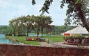
| Date: | |
|---|---|
| Description: | View from a stone bridge towards Vilas Park, with children riding the carousel (merry-go-round) and a kiddie train adjacent to the lagoon. |

| Date: | 1868 |
|---|---|
| Description: | This 1868 birds-eye view depicts the buildings, streets, railroad, vegetation and topography of Columbus, Wisconsin. The high school, cemetery, railroad de... |

| Date: | 1867 |
|---|---|
| Description: | Bird's-eye map of Green Bay and Fort Howard, Brown Co., depicts street names and street layouts, houses, trees, and the East River. A reference key at the ... |

| Date: | 1867 |
|---|---|
| Description: | Bird's-eye map of La Crosse with nine insets of residences, schools, and the Court House and Jail. |

| Date: | 1878 |
|---|---|
| Description: | Bird's-eye map of Chilton with insets of points of interest, including P.H. Becker's Brewery, Chilton House, and Gutheil's Block. |

| Date: | 1874 |
|---|---|
| Description: | Bird's-eye map of Chippewa Falls. |

| Date: | 1891 |
|---|---|
| Description: | Bird's-eye view of Eau Claire. |

| Date: | 1893 |
|---|---|
| Description: | Bird's-eye map of Jefferson, looking north. Crayfish River at left and center, Rock River from upper center to bottom center, joins at left of center; thir... |

| Date: | 12 21 1882 |
|---|---|
| Description: | Bird's-eye map of Kaukauna, from the Appleton Post Annual Review. |
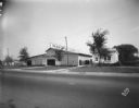
| Date: | 09 19 1928 |
|---|---|
| Description: | Marling Lumber Company, 1801 East Washington Avenue. The Yahara River is to the right, with a bridge in the background. |
If you didn't find the material you searched for, our Library Reference Staff can help.
Call our reference desk at 608-264-6535 or email us at:


