 Filter: Categories of Wisconsin Historical Images
Filter: Subject of Dwellings
Filter: Subject of architecture
Filter: Subject of streams
Filter: Categories of Wisconsin Historical Images
Filter: Subject of Dwellings
Filter: Subject of architecture
Filter: Subject of streams
| Date: | |
|---|---|
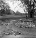
| Description: | Rocks placed to control the flow of Dale Creek. A house is visible in the background. This picture was likely taken as a study of the water drainage in ear... |
| Date: | 05 30 1962 |
|---|---|
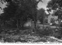
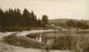
| Description: | A country valley with a winding stream. A farmhouse with barn and silo are on the right. |
| Date: | |
|---|---|
| Description: | View looking north from a covered bridge, including a rocky stream-bed and a tree-lined dirt road with houses and other wooden buildings. Caption reads, "V... |
| Date: | |
|---|---|
| Description: | A farm boy is riding the "hay-fork horse" as the farmer is loading hay into the barn during haying time in July. |
| Date: | 1980 |
|---|---|
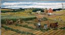
| Description: | Farmers work cooperatively with their horse teams on silo-filling activities early in autumn. Rows of green forage are created in the fields and carried to... |
| Date: | |
|---|---|
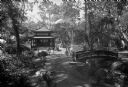
| Description: | View of the Eagles Nest, a Japanese Garden featuring a bridge and building amongst plants and trees. |
| Date: | |
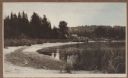
|---|---|
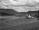
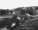
| Description: | Elevated view of a stream with a dam and a bridge. There is a small fenced garden along the water. In the distance is a hillside with houses. |
| Date: | 05 30 1967 |
|---|---|
| Description: | View of a parade traveling through a cemetery. Beyond, barns and farmhouses can be seen. |

| Date: | 1926 |
|---|---|
| Description: | A topographic map of Green County, showing by contours and spot heights the topographic and natural features of the county. The contour intervals are 20 fe... |
| Date: | 1920 |
|---|---|
| Description: | View along shoreline towards a rustic foot bridge which crosses the mouth of Fish Creek, which separates the village of Fish Creek from Peninsula State Par... |

| Date: | 1897 |
|---|---|
| Description: | Topographical map of Stanley McCormick's Riven Rock estate in El Montecito, Santa Barbara County, California. The map is identified as a map of a survey co... |

| Date: | 1897 |
|---|---|
| Description: | This 1897 map of Sawyer County, Wisconsin, shows the township and range system, sections, roads, farm houses, camps, school houses, dams, bridges, Indian r... |
| Date: | 1915 |
|---|---|
| Description: | A rustic foot bridge over Fish Creek connects Peninsula State Park (foreground) with the village of Fish Creek. The Vits house is at the right end of the b... |

| Date: | 1860 |
|---|---|
| Description: | This map of Dodge County, Wisconsin, shows the township and range grid, towns, sections, cities and villages, railroads, roads, property owners and acreage... |

| Date: | 1910 |
|---|---|
| Description: | This 1910 map from the U.S. Post Office Dept. shows rural delivery routes, active and discontinued post offices, collection boxes, selected rural landowner... |

| Date: | 1911 |
|---|---|
| Description: | This 1911 map from the U.S. Post Office Dept. shows rural delivery routes, active and discontinued post offices, collection boxes, selected rural landowner... |

| Date: | 1911 |
|---|---|
| Description: | This 1911 map from the U.S. Post Office Department shows rural delivery routes, active and discontinued post offices, selected rural landowners and houses,... |

| Date: | 1921 |
|---|---|
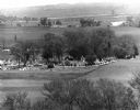
| Description: | Elevated view of Woodstock, with dwellings, farm buildings and a church. Pastures and fields surround the town. |

| Date: | |
|---|---|
| Description: | View from above of Elephant's Foot Rock with Woodstock in the valley below. |
| Date: | 1908 |
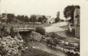
|---|---|
| Description: | View of a street going through the center of town. In the foreground is a stream and a bridge. Commercial buildings and dwellings are on the left. |
If you didn't find the material you searched for, our Library Reference Staff can help.
Call our reference desk at 608-264-6535 or email us at: