 Filter: Categories of Wisconsin Historical Images
Filter: Subject of Dwellings
Filter: Subject of architecture
Filter: Subject of valleys
Filter: Categories of Wisconsin Historical Images
Filter: Subject of Dwellings
Filter: Subject of architecture
Filter: Subject of valleys
| Date: | |
|---|---|
| Description: | View from hill overlooking a farmstead at the base of the hill with a windmill and a pond. On the right in the foreground, two men, one sitting, one standi... |

| Date: | 05 10 1928 |
|---|---|
| Description: | The Lutheran Church and buildings, seen from Lutheran Church Hill. |

| Date: | 11 1951 |
|---|---|
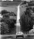
| Description: | Aerial view of US Highway 14 southeast of La Crosse descending into Mormon Coulee. The original caption of the print, which is undated, describes the road ... |
| Date: | 05 30 1962 |
|---|---|
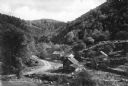
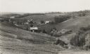
| Description: | A country valley with a winding stream. A farmhouse with barn and silo are on the right. |

| Date: | 1900 |
|---|---|
| Description: | Landscape view of field, trees, and valley with farm buildings in background. A man is driving a horse-drawn reaper in a field in the foreground. |
| Date: | |
|---|---|
| Description: | View of a mountain pass named Dunville Notch. A group of farmhouses are located among trees and a dirt road. |

| Date: | |
|---|---|
| Description: | View of the Fahnestock House with Saddleback Mountain in the background. |

| Date: | |
|---|---|
| Description: | Elevated view of the Blue Ridge Terrace, a large hotel on a mountain overlooking the valley. Cars are parked near the road, and three men are gathered on t... |

| Date: | |
|---|---|
| Description: | Farm buildings standing near the fields at Glen Farm in Dorset Hollow. |
| Date: | 1909 |
|---|---|
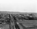
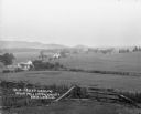
| Description: | An elevated view of a town in the Wisconsin River Valley. Fields surround the town, and low hills are in the far background. |
| Date: | |
|---|---|
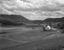
| Description: | Rich Valley looking down at Mill Creek Valley. There are several farmhouses among the fields. |
| Date: | |
|---|---|
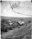
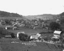
| Description: | View down hill of town in a valley. There is open land, homes, barns and a bee farm. |

| Date: | |
|---|---|
| Description: | View of town showing mountains in the distance. A building in the foreground, located near the water, bears the label "C.M.M. Crath." |

| Date: | |
|---|---|
| Description: | View from hill over church and cemetery towards fields and town in a valley. |

| Date: | 05 1961 |
|---|---|
| Description: | Aerial view of the town of Luang Prabang, Laos. Trees are interspersed among houses and roads and green mountains encircle the town. The golden roof of Pho... |
| Date: | 1925 |
|---|---|
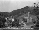
| Description: | Elevated view of the Catholic church, residential homes, with hills and trees in the background. |
| Date: | 08 1983 |
|---|---|
| Description: | "The camera, with a long lens, looks across the valley." |

| Date: | |
|---|---|
| Description: | View from above of Elephant's Foot Rock with Woodstock in the valley below. |
| Date: | 1936 |
|---|---|
| Description: | View down hill towards valley of farming country in the “Coulee Region.” |
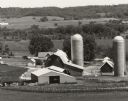
| Date: | 06 1976 |
|---|---|
| Description: | Caption on back of photograph: "Tom Nee farm, 3 miles SE of Richland Center. Looking west over Pine River Valley. Early summer, 1976. TION; RIE; S 1/2 NW 1... |
If you didn't find the material you searched for, our Library Reference Staff can help.
Call our reference desk at 608-264-6535 or email us at: