 Filter: Categories of Wisconsin Historical Images
Filter: Subject of Education
Filter: Community of Milwaukee
Filter: Subject of church buildings
Filter: Categories of Wisconsin Historical Images
Filter: Subject of Education
Filter: Community of Milwaukee
Filter: Subject of church buildings
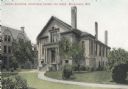
| Date: | 1910 |
|---|---|
| Description: | View across lawn toward the Chapel Building. Small footpaths curve from the left and right to the entrance. Caption reads: "Chapel Building, Industrial Sch... |
| Date: | |
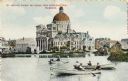
|---|---|
| Description: | St. Josephat Church and School from Kosciuszko Park. The classic style church with dome is across a body of water. Three boats with boaters are out rowing ... |

| Date: | 1912 |
|---|---|
| Description: | Church and school seen from Kosciuszko Park. Located across a lake, behind some trees and bushes. A woman is sitting on some decorative stones next to the ... |

| Date: | 1886 |
|---|---|
| Description: | A hand-colored map of Milwaukee County, Wisconsin that shows the township and range system, sections, towns, roads, railroads and rail stations, cities and... |

| Date: | 1891 |
|---|---|
| Description: | A hand-colored map of Milwaukee County, Wisconsin that shows the township and range system, sections, towns, roads, railroads and rail stations, cities and... |

| Date: | 1902 |
|---|---|
| Description: | A map of Milwaukee County, Wisconsin that shows the township and range system, sections, towns, roads, railroads and rail stations, cities and villages, po... |

| Date: | 1863 |
|---|---|
| Description: | Includes index to public buildings, churches, schools. Inset: Glidden & Lockwood’s addition. Gives names of some property owners. |

| Date: | 05 1958 |
|---|---|
| Description: | Photocopy of a map created by the City of Milwaukee Master Plan Program City Planning Division in May of 1958 representing 1870 "THE CENTRAL AREA OF THE CI... |

| Date: | 1857 |
|---|---|
| Description: | This map shows lot and block numbers, wards, roads, railroads, some landowners’ names, and selected buildings. The map includes an inset map of Glidden & L... |

| Date: | 1857 |
|---|---|
| Description: | This map shows lot and block numbers, wards, roads, railroads, some landowners’ names, and selected buildings. Lake Michigan, the Milwaukee River, and Glid... |

| Date: | 1857 |
|---|---|
| Description: | This map shows lot and block numbers, wards, roads, railroads, some landowners’ names, and selected buildings. Lake Michigan, the Milwaukee River, and Glid... |

| Date: | 1904 |
|---|---|
| Description: | This map has three inset maps of Whitefish Bay, Cudahy, and South Milwaukee. This map depicts schools, engine houses, railroads, street railways, city ward... |
If you didn't find the material you searched for, our Library Reference Staff can help.
Call our reference desk at 608-264-6535 or email us at: