 Filter: Categories of Wisconsin Historical Images
Filter: Subject of Education
Filter: Community of Milwaukee
Filter: Subject of human settlements
Filter: Categories of Wisconsin Historical Images
Filter: Subject of Education
Filter: Community of Milwaukee
Filter: Subject of human settlements

| Date: | 1959 |
|---|---|
| Description: | Elevated view of Central Building. Seven story building with a walkway connecting to the second floor over the road on the right. Cars are parked in front... |
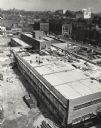
| Date: | 03 1953 |
|---|---|
| Description: | Elevated view of construction of the new building, at Sixth Street and Highland Avenue. The downtown can be seen in the background, including the Schlitz c... |
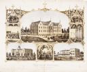
| Date: | 1867 |
|---|---|
| Description: | 1868-1875. Founded by Dr. Joseph Salzman (featured in the vignette at left, teaching). Vignette, lower left, features St. Francis Seminary, founded in 1856... |

| Date: | 03 06 1948 |
|---|---|
| Description: | Aerial view of High School, in the upper half of the image, with fields, trees, and roadways surrounding it. In the lower half is a residential neighborho... |

| Date: | |
|---|---|
| Description: | St. Josephat Church and School from Kosciuszko Park. The classic style church with dome is across a body of water. Three boats with boaters are out rowing ... |

| Date: | 1912 |
|---|---|
| Description: | Church and school seen from Kosciuszko Park. Located across a lake, behind some trees and bushes. A woman is sitting on some decorative stones next to the ... |

| Date: | 1915 |
|---|---|
| Description: | Exterior view of the high school. Caption reads: "Washington High School, Milwaukee." |
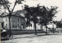
| Date: | 1890 |
|---|---|
| Description: | Exterior of Walter Allen School, with a woman in a carriage parked in front. The Walter Allen School was an elementary school located at 1657 South Third S... |
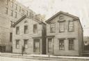
| Date: | 1920 |
|---|---|
| Description: | First location of the high school at 301-303 Fifth Street. Consists of two house-sized buildings, with the entrances close to each other. Sign on front of ... |
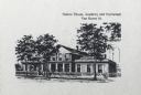
| Date: | |
|---|---|
| Description: | Caption reads: "Sisters' House, Academy and Orphanage Van Buren St." Three trees stand in front of the building. A woman is in front left of center, and tw... |

| Date: | 1910 |
|---|---|
| Description: | The entrance on the left has a small domed tower, and on the right is a chimney. Caption reads: "South Side High School, Milwaukee, Wis." |
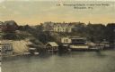
| Date: | 1910 |
|---|---|
| Description: | Elevated view from bridge looking over at a hill leading down to bath houses and fenced-in swimming areas for beginners. Establishment of Wm. Bechstein. Ca... |
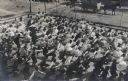
| Date: | 1909 |
|---|---|
| Description: | Elevated view of a large group of school children exercising in the schoolyard. Boys and girls are on separate sides of the yard. All are the students are ... |

| Date: | 1938 |
|---|---|
| Description: | Children standing in line, boarding an International D-300 bus near what appears to be a school building. This bus was equipped with 165" Hicks body. |

| Date: | 1938 |
|---|---|
| Description: | Children standing in line, boarding an International D-300 bus near what appears to be a school buiding. This bus was equipped with 165" Hicks body. |

| Date: | 1886 |
|---|---|
| Description: | A hand-colored map of Milwaukee County, Wisconsin that shows the township and range system, sections, towns, roads, railroads and rail stations, cities and... |

| Date: | 1891 |
|---|---|
| Description: | A hand-colored map of Milwaukee County, Wisconsin that shows the township and range system, sections, towns, roads, railroads and rail stations, cities and... |

| Date: | 1902 |
|---|---|
| Description: | A map of Milwaukee County, Wisconsin that shows the township and range system, sections, towns, roads, railroads and rail stations, cities and villages, po... |

| Date: | 1863 |
|---|---|
| Description: | Includes index to public buildings, churches, schools. Inset: Glidden & Lockwood’s addition. Gives names of some property owners. |

| Date: | 05 1958 |
|---|---|
| Description: | Photocopy of a map created by the City of Milwaukee Master Plan Program City Planning Division in May of 1958 representing 1870 "THE CENTRAL AREA OF THE CI... |
If you didn't find the material you searched for, our Library Reference Staff can help.
Call our reference desk at 608-264-6535 or email us at: