 Filter: Categories of Wisconsin Historical Images
Filter: Subject of Education
Filter: Community of Milwaukee
Filter: Subject of lakes
Filter: Categories of Wisconsin Historical Images
Filter: Subject of Education
Filter: Community of Milwaukee
Filter: Subject of lakes
| Date: | |
|---|---|
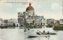
| Description: | St. Josephat Church and School from Kosciuszko Park. The classic style church with dome is across a body of water. Three boats with boaters are out rowing ... |

| Date: | 1912 |
|---|---|
| Description: | Church and school seen from Kosciuszko Park. Located across a lake, behind some trees and bushes. A woman is sitting on some decorative stones next to the ... |

| Date: | 1886 |
|---|---|
| Description: | A hand-colored map of Milwaukee County, Wisconsin that shows the township and range system, sections, towns, roads, railroads and rail stations, cities and... |

| Date: | 1891 |
|---|---|
| Description: | A hand-colored map of Milwaukee County, Wisconsin that shows the township and range system, sections, towns, roads, railroads and rail stations, cities and... |

| Date: | 1863 |
|---|---|
| Description: | Includes index to public buildings, churches, schools. Inset: Glidden & Lockwood’s addition. Gives names of some property owners. |
If you didn't find the material you searched for, our Library Reference Staff can help.
Call our reference desk at 608-264-6535 or email us at: