 Filter: Categories of Wisconsin Historical Images
Filter: Subject of Education
Filter: Community of Milwaukee
Filter: Subject of roads
Filter: Categories of Wisconsin Historical Images
Filter: Subject of Education
Filter: Community of Milwaukee
Filter: Subject of roads
| Date: | 1905 |
|---|---|
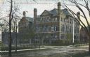
| Description: | Exterior view across street toward the school on a street corner. The school building has five levels, with peaked roofs and several chimneys. A red buildi... |
| Date: | 1910 |
|---|---|
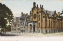
| Description: | The temple is on the right of the Academy at the street corner. Caption reads: "German-English Academy & Temple Emanuel, Milwaukee." |
| Date: | 1906 |
|---|---|
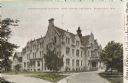
| Description: | Administration building for the school. The building has over three stories, and a covered main entrance. Caption reads: "Administration Building, Industri... |
| Date: | 1940 |
|---|---|
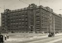
| Description: | Central Building. Six-story building with cars along the road next to it. In the lower foreground is a parking lot with a sign listing parking as 15 cents. |

| Date: | 1959 |
|---|---|
| Description: | Elevated view of Central Building. Seven story building with a walkway connecting to the second floor over the road on the right. Cars are parked in front... |

| Date: | 03 06 1948 |
|---|---|
| Description: | Aerial view of High School, in the upper half of the image, with fields, trees, and roadways surrounding it. In the lower half is a residential neighborho... |

| Date: | 1910 |
|---|---|
| Description: | The entrance on the left has a small domed tower, and on the right is a chimney. Caption reads: "South Side High School, Milwaukee, Wis." |
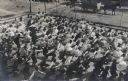
| Date: | 1909 |
|---|---|
| Description: | Elevated view of a large group of school children exercising in the schoolyard. Boys and girls are on separate sides of the yard. All are the students are ... |

| Date: | 1938 |
|---|---|
| Description: | Children standing in line, boarding an International D-300 bus near what appears to be a school buiding. This bus was equipped with 165" Hicks body. |

| Date: | 1886 |
|---|---|
| Description: | A hand-colored map of Milwaukee County, Wisconsin that shows the township and range system, sections, towns, roads, railroads and rail stations, cities and... |

| Date: | 1891 |
|---|---|
| Description: | A hand-colored map of Milwaukee County, Wisconsin that shows the township and range system, sections, towns, roads, railroads and rail stations, cities and... |

| Date: | 1902 |
|---|---|
| Description: | A map of Milwaukee County, Wisconsin that shows the township and range system, sections, towns, roads, railroads and rail stations, cities and villages, po... |

| Date: | 1863 |
|---|---|
| Description: | Includes index to public buildings, churches, schools. Inset: Glidden & Lockwood’s addition. Gives names of some property owners. |

| Date: | 05 1958 |
|---|---|
| Description: | Photocopy of a map created by the City of Milwaukee Master Plan Program City Planning Division in May of 1958 representing 1870 "THE CENTRAL AREA OF THE CI... |

| Date: | 1901 |
|---|---|
| Description: | This map shows public schools, engine houses, railroads, street railways, city wards, parks, block numbers, and Lake Michigan. Also included are indexes, t... |
If you didn't find the material you searched for, our Library Reference Staff can help.
Call our reference desk at 608-264-6535 or email us at: