 Filter: Categories of Wisconsin Historical Images
Filter: Subject of Education
Filter: Community of Milwaukee
Filter: Year of 1800-1899
Filter: Subject of architecture
Filter: Categories of Wisconsin Historical Images
Filter: Subject of Education
Filter: Community of Milwaukee
Filter: Year of 1800-1899
Filter: Subject of architecture
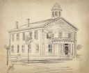
| Date: | 1890 |
|---|---|
| Description: | Drawing of a two-story school house. A bell tower is on the roof, a tree and a lamp post and fence are next to the road. |

| Date: | 1886 |
|---|---|
| Description: | A hand-colored map of Milwaukee County, Wisconsin that shows the township and range system, sections, towns, roads, railroads and rail stations, cities and... |

| Date: | 1891 |
|---|---|
| Description: | A hand-colored map of Milwaukee County, Wisconsin that shows the township and range system, sections, towns, roads, railroads and rail stations, cities and... |

| Date: | 1863 |
|---|---|
| Description: | Includes index to public buildings, churches, schools. Inset: Glidden & Lockwood’s addition. Gives names of some property owners. |

| Date: | 1857 |
|---|---|
| Description: | This map shows lot and block numbers, wards, roads, railroads, some landowners’ names, and selected buildings. The map includes an inset map of Glidden & L... |

| Date: | 1857 |
|---|---|
| Description: | This map shows lot and block numbers, wards, roads, railroads, some landowners’ names, and selected buildings. Lake Michigan, the Milwaukee River, and Glid... |

| Date: | 1857 |
|---|---|
| Description: | This map shows lot and block numbers, wards, roads, railroads, some landowners’ names, and selected buildings. Lake Michigan, the Milwaukee River, and Glid... |
If you didn't find the material you searched for, our Library Reference Staff can help.
Call our reference desk at 608-264-6535 or email us at: