 Filter: Categories of Wisconsin Historical Images
Filter: Subject of Education
Filter: Community of Milwaukee
Filter: Categories of Wisconsin Historical Images
Filter: Subject of Education
Filter: Community of Milwaukee

| Date: | 05 1958 |
|---|---|
| Description: | Photocopy of a map created by the City of Milwaukee Master Plan Program City Planning Division in May of 1958 representing 1870 "THE CENTRAL AREA OF THE CI... |

| Date: | 1964 |
|---|---|
| Description: | A group of protesters march down a street, led by a car. They are protesting school segregation. |
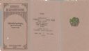
| Date: | 04 21 1919 |
|---|---|
| Description: | Front cover, menu, and back cover of program ("Conferring the Service Stripes") for a dinner at the Medford Hotel, with a deep rose hand-colored border wit... |

| Date: | 1957 |
|---|---|
| Description: | High school student, Judith Castine, leaning on a desk, studying at West Milwaukee High School. |

| Date: | 09 20 1989 |
|---|---|
| Description: | Melodie Albritton holds up an origami crane she folded at St. Nicholas School. |

| Date: | |
|---|---|
| Description: | Elevated view of students in a home economics kitchen classroom at Roosevelt Junior High. |

| Date: | 09 20 1989 |
|---|---|
| Description: | Janine Dagons resting her chin on a table with an origami peace crane sitting in front of her. |
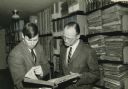
| Date: | 03 1965 |
|---|---|
| Description: | The caption with this photograph reads: "Dr. Walter Peterson (right), professor of history at Lawrence University, Appleton, with F. Gerald Ham, Wisconsin ... |

| Date: | 1857 |
|---|---|
| Description: | This map shows lot and block numbers, wards, roads, railroads, some landowners’ names, and selected buildings. The map includes an inset map of Glidden & L... |

| Date: | 1857 |
|---|---|
| Description: | This map shows lot and block numbers, wards, roads, railroads, some landowners’ names, and selected buildings. Lake Michigan, the Milwaukee River, and Glid... |

| Date: | 1857 |
|---|---|
| Description: | This map shows lot and block numbers, wards, roads, railroads, some landowners’ names, and selected buildings. Lake Michigan, the Milwaukee River, and Glid... |

| Date: | 1892 |
|---|---|
| Description: | This map shows schools, engine houses, railroads, street railways, wards, parks, cemeteries, block numbers, a street index, explanations, and general refer... |

| Date: | 1901 |
|---|---|
| Description: | This map shows public schools, engine houses, railroads, street railways, city wards, parks, block numbers, and Lake Michigan. Also included are indexes, t... |

| Date: | 1904 |
|---|---|
| Description: | This map has three inset maps of Whitefish Bay, Cudahy, and South Milwaukee. This map depicts schools, engine houses, railroads, street railways, city ward... |

| Date: | 1904 |
|---|---|
| Description: | This map shows wards, schools, engine houses, railroads, street railways, block numbers, parks, roads, and Lake Michigan. Also included are indexes: Table ... |

| Date: | 1924 |
|---|---|
| Description: | This map shows streets, selected buildings, railroads, railway yards, schools, parks, schools, cemeteries, bays, the Milwaukee River, and Lake Michigan. De... |

| Date: | 1927 |
|---|---|
| Description: | This map shows street car lines, bus routes, railroads, proposed city boundary lines, wards, public schools, blocks & house numbers, Lake Michigan, one mil... |

| Date: | 1910 |
|---|---|
| Description: | A Sanborn insurance map of Milwaukee, including the shore of Lake Michigan. |

| Date: | |
|---|---|
| Description: | View from back of classroom towards Vel Phillips standing behind a desk. The chalkboard behind her reads: "Protective" and "Public Works." There is a map o... |

| Date: | 1956 |
|---|---|
| Description: | This map shows city, suburban, parochial and other types schools, with an explanation of symbols in the right margin. The original caption for the map read... |
If you didn't find the material you searched for, our Library Reference Staff can help.
Call our reference desk at 608-264-6535 or email us at: