 Filter: Categories of Wisconsin Historical Images
Filter: Subject of Education
Filter: Community of Milwaukee
Filter: Year of 1800-1899
Filter: Categories of Wisconsin Historical Images
Filter: Subject of Education
Filter: Community of Milwaukee
Filter: Year of 1800-1899
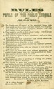
| Date: | 1846 |
|---|---|
| Description: | "Rules to be observed by the pupils of public schools of Milwaukee." |
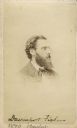
| Date: | 1870 |
|---|---|
| Description: | Vignetted carte-de-visite portrait of Professor Davenport Fisher (1832-1911), Milwaukee chemist. After earning his Ph.D. in Chemistry from Heidelberg Unive... |
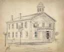
| Date: | 1890 |
|---|---|
| Description: | Drawing of a two-story school house. A bell tower is on the roof, a tree and a lamp post and fence are next to the road. |
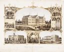
| Date: | 1867 |
|---|---|
| Description: | 1868-1875. Founded by Dr. Joseph Salzman (featured in the vignette at left, teaching). Vignette, lower left, features St. Francis Seminary, founded in 1856... |
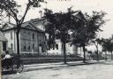
| Date: | 1890 |
|---|---|
| Description: | Exterior of Walter Allen School, with a woman in a carriage parked in front. The Walter Allen School was an elementary school located at 1657 South Third S... |

| Date: | 1886 |
|---|---|
| Description: | A hand-colored map of Milwaukee County, Wisconsin that shows the township and range system, sections, towns, roads, railroads and rail stations, cities and... |

| Date: | 1891 |
|---|---|
| Description: | A hand-colored map of Milwaukee County, Wisconsin that shows the township and range system, sections, towns, roads, railroads and rail stations, cities and... |

| Date: | 1863 |
|---|---|
| Description: | Includes index to public buildings, churches, schools. Inset: Glidden & Lockwood’s addition. Gives names of some property owners. |

| Date: | 1857 |
|---|---|
| Description: | This map shows lot and block numbers, wards, roads, railroads, some landowners’ names, and selected buildings. The map includes an inset map of Glidden & L... |

| Date: | 1857 |
|---|---|
| Description: | This map shows lot and block numbers, wards, roads, railroads, some landowners’ names, and selected buildings. Lake Michigan, the Milwaukee River, and Glid... |

| Date: | 1857 |
|---|---|
| Description: | This map shows lot and block numbers, wards, roads, railroads, some landowners’ names, and selected buildings. Lake Michigan, the Milwaukee River, and Glid... |

| Date: | 1892 |
|---|---|
| Description: | This map shows schools, engine houses, railroads, street railways, wards, parks, cemeteries, block numbers, a street index, explanations, and general refer... |
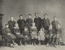
| Date: | 1885 |
|---|---|
| Description: | Formal group portrait of the students attending the Milwaukee Day School for the Oral Instruction of the Deaf. The first public day school for the deaf, es... |

| Date: | 1865 |
|---|---|
| Description: | Carte-de-visite quarter-length vignetted portrait of Katherine Schloesser (later Estabrook), dated via caption to "about Civil War time." Schloesser was a ... |
If you didn't find the material you searched for, our Library Reference Staff can help.
Call our reference desk at 608-264-6535 or email us at: