 Filter: Categories of Wisconsin Historical Images
Filter: Subject of Engraving
Filter: Subject of intellectual life
Filter: Subject of service industries
Filter: Categories of Wisconsin Historical Images
Filter: Subject of Engraving
Filter: Subject of intellectual life
Filter: Subject of service industries
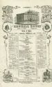
| Date: | 02 22 1860 |
|---|---|
| Description: | Menu for the Newhall House hotel in Milwaukee, extensively illustrated with an engraving of the hotel and prices. The Newhall House, during its day one of ... |
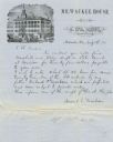
| Date: | 1857 |
|---|---|
| Description: | Letter on stationery featuring an engraving of an exterior view of the Milwaukee House showing horse-drawn vehicles and people standing on the sidewalk in ... |
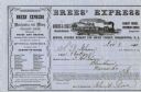
| Date: | 11 08 1860 |
|---|---|
| Description: | Receipt for a package delivered to Brees' Express via Morris & Essex Railroad. There is an engraving of a train traveling through a rural landscape near th... |
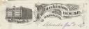
| Date: | |
|---|---|
| Description: | Letterhead of Plankinton House in Milwaukee, Wisconsin, with a three-quarter view of the hotel and traffic in the street, including people on foot, on hors... |

| Date: | |
|---|---|
| Description: | Memohead of the Milwaukee Dry Dock Company, which operated two docks, with a view of a dock with ships, planks of wood, buildings, and the slogan, "Electri... |
| Date: | 11 26 1898 |
|---|---|
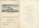
| Description: | Menu for a "Banquet tendered by the Union Iron Works to the Delegation from the Badger State" given at the Palace Hotel, with an etching of the Battleship ... |
| Date: | 1891 |
|---|---|
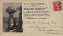
| Description: | H.H. Bennett advertising envelope addressed to William H. Metcalf of Milwaukee. The envelope bears an engraved image of people standing on top of Stand Roc... |

| Date: | 1720 |
|---|---|
| Description: | One of Herman Moll's most famous maps, often referred to as The Beaver Map for its elaborate engraved inset depicting and describing beavers building a dam... |

| Date: | 1767 |
|---|---|
| Description: | Map of the north east coast of America, showing colonial borders, cities, Native American land, lakes, rivers, and a few hills and mountains. Illustrated t... |

| Date: | 1780 |
|---|---|
| Description: | Detailed map of America east of the Louisiana region. It shows forts, cities, borders and boundary lines, Native American land, the post road, mountains, w... |
If you didn't find the material you searched for, our Library Reference Staff can help.
Call our reference desk at 608-264-6535 or email us at: