 Filter: Categories of Wisconsin Historical Images
Filter: Subject of Explorers
Filter: Subject of intellectual life
Filter: Subject of land
Filter: Categories of Wisconsin Historical Images
Filter: Subject of Explorers
Filter: Subject of intellectual life
Filter: Subject of land

| Date: | 1632 |
|---|---|
| Description: | The Wisconsin portion of Champlain's 1632 map, augmented since the previous one, for navigation according to the true Meridien, by Sieur de Champlain. The ... |
| Date: | 03 30 1938 |
|---|---|
| Description: | Mrs. Attilio Gatti carried by four Congolese men during her husband's expedition to the African Congo. The expedition was sponsored by the International Ha... |
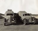
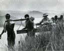
| Date: | 1938 |
|---|---|
| Description: | Two specially designed International trucks connected with an awning at an African camp site. The camp site was home to an Attilio Gatti expedition. The sp... |

| Date: | |
|---|---|
| Description: | A painting depicting Marquette and Joliet in a birch bark canoe with two other men during their excursion on the Mississippi River, which they discovered o... |

| Date: | 1835 |
|---|---|
| Description: | This hand-colored map shows the area from Michigan west to the Missouri River and Lake Winnipeg, and includes expedition routes of Stephen H. Long and Henr... |

| Date: | 1720 |
|---|---|
| Description: | Double hemispherical world map showing routes of Tasman, Magellan, Mendana, etc. Relief shown pictorially. Title in oak wreath cartouche. Map between four ... |
If you didn't find the material you searched for, our Library Reference Staff can help.
Call our reference desk at 608-264-6535 or email us at: