 Filter: Categories of Wisconsin Historical Images
Filter: Subject of Explorers
Filter: Subject of maps
Filter: Categories of Wisconsin Historical Images
Filter: Subject of Explorers
Filter: Subject of maps
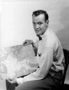
| Date: | 08 31 1953 |
|---|---|
| Description: | Arthur Constable displays the route of his 10-month travel route through Europe and North Africa on a map. |

| Date: | 07 21 1951 |
|---|---|
| Description: | Luncheon menu for the S.S. Argentina, with a map of Argentina with spot illustrations for the provinces and featured products or symbols, the coat o... |

| Date: | 1735 |
|---|---|
| Description: | A map of the western hemisphere, including parts of western Europe and Africa. Portraits of explorers, such as Jacques Marquette, Louis Joliet, and Robert ... |

| Date: | 1710 |
|---|---|
| Description: | A seminal and fairly accurate map of the Great Lakes Region up to Baffin's Bay in Northern Canada. This is possibly the first printed map to locate Detroit... |
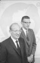
| Date: | 06 12 1958 |
|---|---|
| Description: | Antarctic explorers Dr. Edward Thiel (left) and John Behrendt (right) recently returned from a year long stay in Antarctica. Dr. Thiel was the co-leader of... |
If you didn't find the material you searched for, our Library Reference Staff can help.
Call our reference desk at 608-264-6535 or email us at: