 Filter: Categories of Wisconsin Historical Images
Filter: Subject of Explorers
Filter: Subject of water
Filter: Subject of cities and towns
Filter: Categories of Wisconsin Historical Images
Filter: Subject of Explorers
Filter: Subject of water
Filter: Subject of cities and towns

| Date: | 1957 |
|---|---|
| Description: | Large Letter style postcard for Green Bay depicting various scenes in the letters that spell the name of the city. Caption reads: "Greetings from Green Bay... |

| Date: | 08 24 1899 |
|---|---|
| Description: | Pen-and-ink and color on paper. Also shows probable routes of the French explorers Constant le Marchand de Lignery in 1728 and Louis de la Porte de Louvign... |
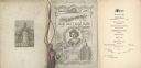
| Date: | 02 22 1892 |
|---|---|
| Description: | Back cover, front cover, and menu page for the Old Settlers' Club of Milwaukee County annual banquet. The back page includes an illustration of a monument ... |

| Date: | 1735 |
|---|---|
| Description: | A map of the western hemisphere, including parts of western Europe and Africa. Portraits of explorers, such as Jacques Marquette, Louis Joliet, and Robert ... |

| Date: | 1710 |
|---|---|
| Description: | A seminal and fairly accurate map of the Great Lakes Region up to Baffin's Bay in Northern Canada. This is possibly the first printed map to locate Detroit... |
If you didn't find the material you searched for, our Library Reference Staff can help.
Call our reference desk at 608-264-6535 or email us at: