Filter: Categories of Wisconsin Historical Images
Filter: Subject of Express highways
Filter: Subject of express highways
Filter: Year of 1900-1999
Filter: Creator Name of Standard Map Company
Filter: Categories of Wisconsin Historical Images
Filter: Subject of Express highways
Filter: Subject of express highways
Filter: Year of 1900-1999
Filter: Creator Name of Standard Map Company

| Date: | 1926 |
|---|---|
| Description: | This 1926 map of Sawyer County, Wisconsin, the township and range system, towns, sections, cities and villages, railroads, highways and roads, and lakes an... |

| Date: | 1930 |
|---|---|
| Description: | This road map of Chippewa County, Wisconsin, dates to around 1930. It shows the township and range grid, towns, sections, cities and villages, railroads, l... |
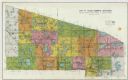
| Date: | 1926 |
|---|---|
| Description: | Map of Eau Claire County, Wisconsin Shows highways, railroads, hydrography, and townships. |

| Date: | 1930 |
|---|---|
| Description: | This map shows schools, school districts, town sections, highways, railroads, and hydrography of the area around Hurley. The right margin includes and expl... |
If you didn't find the material you searched for, our Library Reference Staff can help.
Call our reference desk at 608-264-6535 or email us at: