 Filter: Categories of Wisconsin Historical Images
Filter: Subject of Express highways
Filter: Subject of intellectual life
Filter: Creator Name of Unknown
Filter: Categories of Wisconsin Historical Images
Filter: Subject of Express highways
Filter: Subject of intellectual life
Filter: Creator Name of Unknown

| Date: | 1965 |
|---|---|
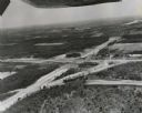
| Description: | Aerial view of town and Highway 66. |

| Date: | 1998 |
|---|---|
| Description: | North-facing aerial view of the interchange between Interstates 39/90 and US Routes 12/18 in the southeast of Madison. Femrite Drive can be seen passing be... |
| Date: | 1960 |
|---|---|
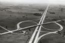
| Description: | Aerial view of the intersection of the interstate highway with USH 12 between Baraboo and Lake Delton with the initial grading largely completed. |

| Date: | 1960 |
|---|---|
| Description: | Aerial view of the construction of the interstate highway near Mirror Lake, showing only the early stages of the bridge construction. |
| Date: | 1967 |
|---|---|
| Description: | Intersection of US Highway 41 and Wisconsin Highway 26 near Oshkosh. |

| Date: | 1979 |
|---|---|
| Description: | Aerial view of Interstate I-90/94 at Camp Douglas, looking northwest. |
| Date: | 1979 |
|---|---|
| Description: | Interstate I-90 and State Highway 35 at La Crosse. |

| Date: | 10 16 1962 |
|---|---|
| Description: | The intersection of Interstate Highway I-90 and USH 12/18 east of Madison. This view looks toward the southeast |

| Date: | 1975 |
|---|---|
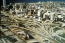
| Description: | Aerial view of Milwaukee County Stadium and the intersection of US 41 and I-94. County Stadium was built in 1953 and demolished in 2001. Although undated... |

| Date: | 1965 |
|---|---|
| Description: | Aerial view of early construction at the Marquette Interchange in Milwaukee, the junction of Interstate Highways I94 and I43. Construction began in 1964, ... |
| Date: | |
|---|---|
| Description: | Aerial view of the first Marquette Interchange, photographed some time after its completion in 1968. |

| Date: | 04 01 1975 |
|---|---|
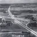
| Description: | The bridge over the Milwaukee Harbor named in honor of former Mayor Daniel Hoan. The bridge was constructed between 1970 and 1972, but during the period de... |

| Date: | 1950 |
|---|---|
| Description: | Divided highway is South Chase Avenue between West Lincoln Avenue (2300) and East Oklahoma Avenue (3100). |

| Date: | 1961 |
|---|---|
| Description: | View over beltline of University of Wisconsin-Madison Arboretum along Lake Wingra. Lake Mendota is on upper left, and Lake Monona is on the right, with the... |

| Date: | 08 08 1973 |
|---|---|
| Description: | At a press conference northern representatives joined together to press their respective states to use newly appropriated funds to improve U.S. Highway 2 f... |

| Date: | 1975 |
|---|---|
| Description: | This map shows nature trails, public attractions, public hunting and fishing grounds, dams, waysides, lakes, highways, and roads. The upper right corner in... |
If you didn't find the material you searched for, our Library Reference Staff can help.
Call our reference desk at 608-264-6535 or email us at: