 Filter: Categories of Wisconsin Historical Images
Filter: Subject of Express highways
Filter: Subject of intellectual life
Filter: Subject of roads
Filter: Type of Photograph
Filter: Categories of Wisconsin Historical Images
Filter: Subject of Express highways
Filter: Subject of intellectual life
Filter: Subject of roads
Filter: Type of Photograph

| Date: | 1965 |
|---|---|
| Description: | Aerial view of town and Highway 66. |

| Date: | 1960 |
|---|---|
| Description: | Aerial view of the construction of the interstate highway near Mirror Lake, showing only the early stages of the bridge construction. |
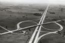
| Date: | 1967 |
|---|---|
| Description: | Intersection of US Highway 41 and Wisconsin Highway 26 near Oshkosh. |

| Date: | 1961 |
|---|---|
| Description: | View over beltline of University of Wisconsin-Madison Arboretum along Lake Wingra. Lake Mendota is on upper left, and Lake Monona is on the right, with the... |

| Date: | 1930 |
|---|---|
| Description: | Exterior view of the Triangle filling station on Highway 12, which sold gasoline, ice, and other items. A man stands in front by the gas pump, and a map of... |
If you didn't find the material you searched for, our Library Reference Staff can help.
Call our reference desk at 608-264-6535 or email us at: