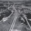
| Date: | 1998 |
|---|---|
| Description: | North-facing aerial view of the interchange between Interstates 39/90 and US Routes 12/18 in the southeast of Madison. Femrite Drive can be seen passing be... |

| Date: | 1979 |
|---|---|
| Description: | Aerial view of Interstate I-90/94 at Camp Douglas, looking northwest. |

| Date: | 1935 |
|---|---|
| Description: | This map is presented by Conoco, and shows the major roads, cities, lakes, and rivers, as well as some of the neighboring states. It includes an index, sca... |

| Date: | 1935 |
|---|---|
| Description: | This blue lined map shows the major roads and cities of Wisconsin. The map includes an index, hotel and cafe advertisements, as well as advertisements for ... |

| Date: | 1935 |
|---|---|
| Description: | This blue lined map ("compliments of Black Eagle Oil Company") shows the major roads and cities of Wisconsin. The map includes an index, hotel and cafe adv... |

| Date: | 1975 |
|---|---|
| Description: | This map shows nature trails, public attractions, public hunting and fishing grounds, dams, waysides, lakes, highways, and roads. The upper right corner in... |
If you didn't find the material you searched for, our Library Reference Staff can help.
Call our reference desk at 608-264-6535 or email us at: