 Filter: Categories of Wisconsin Historical Images
Filter: Subject of Farmhouses
Filter: Subject of human settlements
Filter: Subject of water
Filter: Categories of Wisconsin Historical Images
Filter: Subject of Farmhouses
Filter: Subject of human settlements
Filter: Subject of water
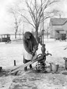
| Date: | 04 1923 |
|---|---|
| Description: | A bundled-up woman hand pumps water from a well into a pail. The ground is covered with ice and snow. Two cars and a farmhouse are in the background. |
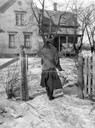
| Date: | 04 1923 |
|---|---|
| Description: | Woman carrying a bucket of water back to her farmhouse in winter. |

| Date: | 1895 |
|---|---|
| Description: | View of a mill, sluice and dam on Waumandee Creek. The mill was built by John Oschner in 1863. Two products produced by the mill were White Rose Flour and ... |
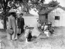
| Date: | 1917 |
|---|---|
| Description: | A group of people under a tree in a farmyard, with possibly a lake in the background. Two women, with heavy netting on their hats, hold luggage. A toddler ... |
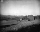
| Date: | 1900 |
|---|---|
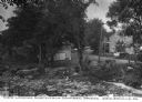
| Description: | Rural scene of farmstead with a river or stream (?) in the background. The farm is bounded by a barbed wire fence, and there is a utility pole on the bank ... |

| Date: | |
|---|---|
| Description: | Elevated view of mill pond and homes along the opposite shoreline. A person is standing at the shoreline in the foreground. Caption reads, "Mill Pond, Mill... |
| Date: | |
|---|---|
| Description: | View looking north from a covered bridge, including a rocky stream-bed and a tree-lined dirt road with houses and other wooden buildings. Caption reads, "V... |

| Date: | |
|---|---|
| Description: | Colorized postcard of the horseshoe curve of railroad tracks. Elevated view of the railroad tracks with train snaking past a farmhouse and a bridge suspend... |
| Date: | 05 15 1909 |
|---|---|
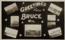
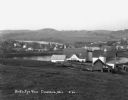
| Description: | Photographic postcard of a poster promoting Bruce with seven photographs. The fairgrounds, Main Street, farm scene, Catholic Church, Chippewa River bridge,... |
| Date: | |
|---|---|
| Description: | The Richardson Farm stands at the far edge of a farm field with a creek running through it and animals grazing. The farmhouse is white and surrounded by tr... |
| Date: | |
|---|---|
| Description: | Elevated view of farmland. In the bottom-left center, there is a structure with a bell tower near a dirt road. In the center there is a similar building. T... |
| Date: | 1930 |
|---|---|
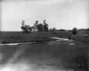
| Description: | View from hill of a farm near a pond. There are homes along the far shoreline, and a lake and hills in the far background. |

| Date: | 02 16 1978 |
|---|---|
| Description: | "The long lens compresses this view from the frozen Rock River in the foreground, the Catholic cemetery, and the Haag farm buildings in the distance." |

| Date: | 1944 |
|---|---|
| Description: | Continental Transportation Lines, Inc. operating an International truck tractor on an urban highway. A bridge, houses and industrial buildings are in the b... |

| Date: | 1904 |
|---|---|
| Description: | Panoramic view of Governor Nelson Dewey's estate. The left image is of an old stone barn with a shed in the rear. The center image is another barn. The rig... |

| Date: | 1897 |
|---|---|
| Description: | This 1897 map of Sawyer County, Wisconsin, shows the township and range system, sections, roads, farm houses, camps, school houses, dams, bridges, Indian r... |

| Date: | 1902 |
|---|---|
| Description: | This 1902 map of the eastern portion of Sawyer County, Wisconsin, shows the township and range system, sections, roads, farm houses, camps, school houses, ... |

| Date: | 1919 |
|---|---|
| Description: | This 1919 map of Sawyer County, Wisconsin, shows the township and range system, sections, cities and villages, roads, railroads, farm houses, the Indian re... |
| Date: | |
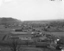
|---|---|
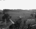
| Description: | View down hill towards Stoddard, with the Mississippi River and hills in the background. The German Lutheran Church is in the foreground, and there are rai... |

| Date: | 1857 |
|---|---|
| Description: | Map of La Crosse County, Wisconsin showing village plat, farm houses, schools, roads, railroads, township names (New Amsterdam, Dacota, Minnesota, Driesbac... |
If you didn't find the material you searched for, our Library Reference Staff can help.
Call our reference desk at 608-264-6535 or email us at: