 Filter: Categories of Wisconsin Historical Images
Filter: Subject of Farmhouses
Filter: Subject of human settlements
Filter: Categories of Wisconsin Historical Images
Filter: Subject of Farmhouses
Filter: Subject of human settlements

| Date: | 1904 |
|---|---|
| Description: | Panoramic view of Governor Nelson Dewey's estate. The left image is of an old stone barn with a shed in the rear. The center image is another barn. The rig... |

| Date: | 1897 |
|---|---|
| Description: | This 1897 map of Sawyer County, Wisconsin, shows the township and range system, sections, roads, farm houses, camps, school houses, dams, bridges, Indian r... |

| Date: | 1902 |
|---|---|
| Description: | This 1902 map of the eastern portion of Sawyer County, Wisconsin, shows the township and range system, sections, roads, farm houses, camps, school houses, ... |

| Date: | 1919 |
|---|---|
| Description: | This 1919 map of Sawyer County, Wisconsin, shows the township and range system, sections, cities and villages, roads, railroads, farm houses, the Indian re... |

| Date: | 1877 |
|---|---|
| Description: | Shows land ownership by name, churches, schools, farm houses, wagon roads, railroads. Includes directory of businesses for Columbus, Portage, Doylestown, W... |

| Date: | 1910 |
|---|---|
| Description: | Shows land for sale by Rusk Farm Co. in Rusk and Chippewa Counties, as well as farmhouses, roads, and railroads. |

| Date: | 1900 |
|---|---|
| Description: | Shows lands belonging to Wisconsin Timber and Land Co., towns, post offices, saw mills, creameries, camps, churches, schools, farm houses, town halls, rail... |
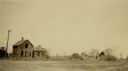
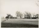
| Date: | 05 17 1935 |
|---|---|
| Description: | View of abandoned homes and other structures. |
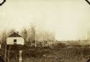
| Date: | 1935 |
|---|---|
| Description: | View of the dilapidated farm from which the Brundage family moved with the assistance of The United States Resettlement Administration. |
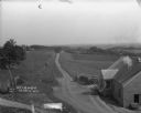
| Date: | 1912 |
|---|---|
| Description: | A scenic view over rolling hills with a road leading to the horizon. There are trees, fields and farm buildings on the left. In the foreground on the right... |
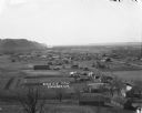
| Date: | |
|---|---|
| Description: | View down hill towards Stoddard, with the Mississippi River and hills in the background. The German Lutheran Church is in the foreground, and there are rai... |
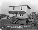
| Date: | |
|---|---|
| Description: | The Elmer Willis Sesl (sp?) farm. The photograph has the term "Exhibit "B"" written on the front in ink. |

| Date: | 1857 |
|---|---|
| Description: | Map of La Crosse County, Wisconsin showing village plat, farm houses, schools, roads, railroads, township names (New Amsterdam, Dacota, Minnesota, Driesbac... |

| Date: | 09 21 1931 |
|---|---|
| Description: | Tornado damage showing a broken, twisted tree laying on the ground and on the roof of a farmhouse. The roof and wall have been crushed. |

| Date: | 09 21 1931 |
|---|---|
| Description: | View from road of storm damage to a farm. The barn roof has blown off. Men are working on the roof, which has exposed roof timbers. In the foreground are t... |
| Date: | 08 07 1924 |
|---|---|
| Description: | View across yard of a storm-damaged farmhouse. In the foreground is an overturned automobile. The windows of the house have been blown out and the roof has... |

| Date: | 08 16 1925 |
|---|---|
| Description: | View of field full of parked automobiles at the commemoration of the 80th anniversary of the founding of the Swiss Colony at New Glarus. A log structure in... |

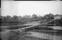
| Date: | |
|---|---|
| Description: | View down railroad tracks of a railroad bridge, which has framed beams on the sides and top. A boy and girl are standing and posing on the bridge. Signs ar... |
| Date: | 1918 |
|---|---|
| Description: | View looking down low hill towards a narrow footbridge which crosses a small river to a village composed of wooden buildings with wooden fences. On the rig... |

| Date: | 1910 |
|---|---|
| Description: | Photographic postcard view of a family posed on a hill in front of a farm, with farmhouse, outbuildings, and a windmill. The family is gathered on a hill i... |
If you didn't find the material you searched for, our Library Reference Staff can help.
Call our reference desk at 608-264-6535 or email us at: