Filter: Categories of Wisconsin Historical Images
Filter: Subject of Farmhouses
Filter: Subject of roads
Filter: Subject of intellectual life
Filter: Categories of Wisconsin Historical Images
Filter: Subject of Farmhouses
Filter: Subject of roads
Filter: Subject of intellectual life

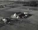
| Date: | 1945 |
|---|---|
| Description: | Aerial view of the "powder storage area" of the Badger Ordnance Plant. |

| Date: | 11 1951 |
|---|---|
| Description: | Aerial view of US Highway 14 southeast of La Crosse descending into Mormon Coulee. The original caption of the print, which is undated, describes the road ... |
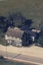
| Date: | |
|---|---|
| Description: | Hand-tinted aerial photograph of the Apps Farm in the Wild Rose vicinity. |
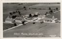
| Date: | 1931 |
|---|---|
| Description: | Aerial view of a farm complex, including a farmhouse and several large buildings. Caption reads: "Wern Farms, Waukesha, Wis." |
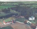
| Date: | 10 05 1948 |
|---|---|
| Description: | Aerial photograph of the Baumgartner Dairy Farm, one half mile east of Three Lakes, WI. |
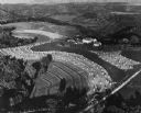
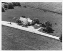
| Date: | 1948 |
|---|---|
| Description: | Aerial view of terraced farm land with shocks of harvested corn. A farm is in the valley and trees cover much of the hills. |
If you didn't find the material you searched for, our Library Reference Staff can help.
Call our reference desk at 608-264-6535 or email us at: