 Filter: Categories of Wisconsin Historical Images
Filter: Subject of Farmhouses
Filter: Subject of rural areas
Filter: Subject of roads
Filter: Categories of Wisconsin Historical Images
Filter: Subject of Farmhouses
Filter: Subject of rural areas
Filter: Subject of roads
| Date: | 1912 |
|---|---|
| Description: | Exterior of the Droster farm located on Felland Road. The house was built in 1854. |
| Date: | |
|---|---|
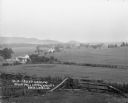
| Description: | Rich Valley looking down at Mill Creek Valley. There are several farmhouses among the fields. |
| Date: | |
|---|---|
| Description: | Elevated view of farmland. In the bottom-left center, there is a structure with a bell tower near a dirt road. In the center there is a similar building. T... |
| Date: | |
|---|---|
| Description: | A bird's-eye view of a farmland property with barns and farmhouse. |
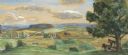
| Date: | 1948 |
|---|---|
| Description: | Prior to the 1948 State Fair, artist Robert Hodgell traveled Wisconsin to study its many landscapes. He then produced a series of study sketches outlining ... |
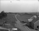
| Date: | 1912 |
|---|---|
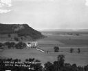
| Description: | A scenic view over rolling hills with a road leading to the horizon. There are trees, fields and farm buildings on the left. In the foreground on the right... |

| Date: | |
|---|---|
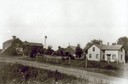
| Description: | Elevated photographic postcard view of a busy road near Blanchardville. Men are driving a wagon hitched to eight horses, and people are standing in the roa... |

| Date: | |
|---|---|
| Description: | Looking up dirt road towards a farm on both sides of the road. There is pasture with sheep on the left. One sheep is in the road. The farmhouse, windmill a... |

| Date: | |
|---|---|
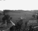
| Description: | View across road and field towards a farm. The farmhouse is on the right, with farm buildings on the left. A two-horse cart is in the center. |

| Date: | |
|---|---|
| Description: | Outdoor group portrait of a family at their farm. The family is posing on the far right in the yard. On the left near the house is a windmill with a sign f... |

| Date: | 1927 |
|---|---|
| Description: | This Blue line print map shows trade area boundaries, lakes, farm homes, railways, high schools, public highways, and townships. A symbol key is included i... |

| Date: | 10 18 1978 |
|---|---|
| Description: | View down Old Sauk Pass towards a house in a valley during a rainstorm in rural Wisconsin. |

| Date: | |
|---|---|
| Description: | A vintage view of an abandoned farmhouse on Highway 39 between Linden and Mineral Point, and a modern view of a house on the same location. The images are ... |
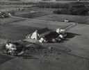
| Date: | 10 05 1948 |
|---|---|
| Description: | Aerial photograph of the Baumgartner Dairy Farm, one half mile east of Three Lakes, WI. |
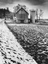
| Date: | 1979 |
|---|---|
| Description: | A barn and silo, on a snow covered farm along Highway 78, between Mt. Horeb and Black Earth. The farmhouse is behind the barn. A barbed wire fence lines th... |
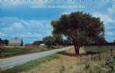
| Date: | 1950 |
|---|---|
| Description: | Text on front reads: "Greetings from Spring Green, Wis." A country road curves to the left around a farm. On the right are a tree, fields and a fence with ... |
If you didn't find the material you searched for, our Library Reference Staff can help.
Call our reference desk at 608-264-6535 or email us at: