 Filter: Categories of Wisconsin Historical Images
Filter: Subject of Farmhouses
Filter: Year of 1800-1899
Filter: Subject of water
Filter: Categories of Wisconsin Historical Images
Filter: Subject of Farmhouses
Filter: Year of 1800-1899
Filter: Subject of water

| Date: | 1870 |
|---|---|
| Description: | A family stands on the porch of small frame house with wing additions. A well is on the far left, and farm buildings are in the background. |
| Date: | 1874 |
|---|---|
| Description: | A unusual scene on an unidentified farmstead probably located near Pleasant Springs, Wisconsin. A family is posed in the yard of a frame house, as is usual... |

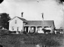
| Date: | 1870 |
|---|---|
| Description: | Family sitting in chairs in front of fence, with two men standing behind the fence near a well wearing top hats. A frame house with a porch is behind them. |

| Date: | 1856 |
|---|---|
| Description: | The Ludemann's [also spelled Lueddemann] farm had been cultivated since the early 1850s by Mr. Ludemann, "a very pleasant Saxon with his very pleasant wife... |
| Date: | 1858 |
|---|---|
| Description: | Hölzlhuber located this farm at about three German miles from Stevens Point. The region's soil was quite fertile. A wooden dwelling house stood in the mids... |

| Date: | 1858 |
|---|---|
| Description: | On a very hot day in August 1858 Hölzlhuber visited the farm of Jack Smith, an Irishman who had immigrated to Canada eleven years previously with his wife ... |

| Date: | 1858 |
|---|---|
| Description: | Hofmann and three sons had emigrated in 1848 from the Rhine region to northern Wisconsin. Initially they had no neighbors for a distance of four to five ho... |

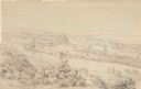
| Date: | 1895 |
|---|---|
| Description: | View of a mill, sluice and dam on Waumandee Creek. The mill was built by John Oschner in 1863. Two products produced by the mill were White Rose Flour and ... |
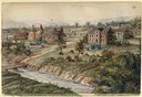
| Date: | 1852 |
|---|---|
| Description: | Landscape view of Fort Snelling, Minnesota Territory from a nearby hill showing the Fort, the Mississippi river, the countryside, farm buildings and tipis.... |

| Date: | 1897 |
|---|---|
| Description: | This 1897 map of Sawyer County, Wisconsin, shows the township and range system, sections, roads, farm houses, camps, school houses, dams, bridges, Indian r... |

| Date: | 1857 |
|---|---|
| Description: | Map of La Crosse County, Wisconsin showing village plat, farm houses, schools, roads, railroads, township names (New Amsterdam, Dacota, Minnesota, Driesbac... |

| Date: | 1895 |
|---|---|
| Description: | View across water towards a house on the banks of the Mississippi River at the base of rocky bluffs. Probably located between Alma and Nelson, along Beef S... |
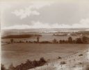
| Date: | 1892 |
|---|---|
| Description: | An elevated view of a gently rolling landscape with cows grazing in the middle distance. At right is a farmhouse and outbuildings. Young trees have been pl... |
If you didn't find the material you searched for, our Library Reference Staff can help.
Call our reference desk at 608-264-6535 or email us at: