 Filter: Categories of Wisconsin Historical Images
Filter: Subject of Farms
Filter: Subject of cheese
Filter: Categories of Wisconsin Historical Images
Filter: Subject of Farms
Filter: Subject of cheese

| Date: | 1928 |
|---|---|
| Description: | Shows different types of roads, railroads, schools, churches, farmsteads, cheese factories, mine shafts, old surface workings, streams, old sulphur pits, a... |
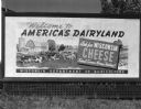
| Date: | |
|---|---|
| Description: | Wisconsin Department of Agriculture billboard promoting Wisconsin cheese with a picture of several cows on a farm. |
If you didn't find the material you searched for, our Library Reference Staff can help.
Call our reference desk at 608-264-6535 or email us at: