 Filter: Categories of Wisconsin Historical Images
Filter: Subject of Farms
Filter: Subject of maps
Filter: Categories of Wisconsin Historical Images
Filter: Subject of Farms
Filter: Subject of maps

| Date: | 1925 |
|---|---|
| Description: | A map of the farm planned by Edwin Bottomley in 1844. |
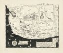
| Date: | |
|---|---|
| Description: | A pen drawing, in the style of a birds-eye map, of Frank and Delia King's estate Folly Farm in Kissimee, Florida. |
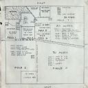
| Date: | 01 24 1924 |
|---|---|
| Description: | Plot for an International Harvester Company demonstration farm. |

| Date: | 1913 |
|---|---|
| Description: | This photocopy map shows plots with owners' names, land use both commercial and agricultural, and lot outlines on University land. Lake Mendota is labeled ... |

| Date: | 1775 |
|---|---|
| Description: | Map of Boston and surrounding regions, from Massachusetts Bay to the Connecticut River, and including part of southern New Hampshire. It shows the colonies... |
If you didn't find the material you searched for, our Library Reference Staff can help.
Call our reference desk at 608-264-6535 or email us at: