Filter: Categories of Wisconsin Historical Images
Filter: Subject of Farms
Filter: Subject of rivers
Filter: Categories of Wisconsin Historical Images
Filter: Subject of Farms
Filter: Subject of rivers

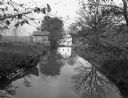
| Date: | 1834 |
|---|---|
| Description: | Peck-a-ton-oka (Pecatonica River) with Rodolf farm in the background. |
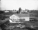
| Date: | |
|---|---|
| Description: | Knapp-Stout and Company Sawmill on the Red Cedar River, with dam and logs in the foreground. |
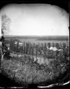
| Date: | |
|---|---|
| Description: | View from hill over a valley dotted with farmsteads and a meandering stream in the foreground. A group of three or four people are posing at the opposite s... |

| Date: | 1943 |
|---|---|
| Description: | This photocopy map shows inhabited farms, rivers, roads, and mills in the vicinity of Marathon City [and village of Edgar], including area between the Big ... |
| Date: | 1875 |
|---|---|
| Description: | View, through a cornfield, of people, a store, a sawmill and wagons. Moscow was platted in 1850 by an Englishman, Chauncy Smith, who dammed the Bluemound ... |
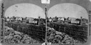
| Date: | 1876 |
|---|---|
| Description: | Probably one of the "Three different views of the village of Argyle, Wis." mentioned in Dahl's 1877 "Catalogue of Stereoscopic Views." A view of the town a... |
| Date: | 1858 |
|---|---|
| Description: | Hölzlhuber located this farm at about three German miles from Stevens Point. The region's soil was quite fertile. A wooden dwelling house stood in the mids... |

| Date: | 1858 |
|---|---|
| Description: | On a very hot day in August 1858 Hölzlhuber visited the farm of Jack Smith, an Irishman who had immigrated to Canada eleven years previously with his wife ... |
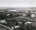
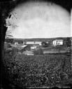
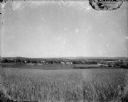
| Date: | 1860 |
|---|---|
| Description: | Elevated view of the Janesville Countryside. |

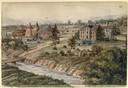
| Date: | 1919 |
|---|---|
| Description: | This is a collection of three hand-colored plat maps. One map is a plat plan and includes annotations and an index that shows public land, business, indust... |
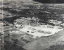
| Date: | 1955 |
|---|---|
| Description: | Aerial view of Valley Fair Mall, with a residential area beyond it on both sides of a river, all surrounded by trees and farmland. |
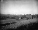
| Date: | 1900 |
|---|---|
| Description: | Rural scene of farmstead with a river or stream (?) in the background. The farm is bounded by a barbed wire fence, and there is a utility pole on the bank ... |

| Date: | 1914 |
|---|---|
| Description: | Slightly elevated view of a man driving three women in an International Model M truck along a rural road. In the background is a valley with farm buildings... |
| Date: | 1920 |
|---|---|
| Description: | A view of a rolling rural landscape, most likely in Sauk County. In the far distance are houses and farm buildings, a church and a larger building, center ... |

| Date: | 1900 |
|---|---|
| Description: | Three men use a McCormick grain binder in a field overlooking a body of water, probably the Saint John River, in Fredericton, New Brunswick, Canada. Men an... |

| Date: | |
|---|---|
| Description: | Colorized postcard of the horseshoe curve of railroad tracks. Elevated view of the railroad tracks with train snaking past a farmhouse and a bridge suspend... |
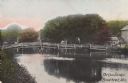
| Date: | |
|---|---|
| Description: | Colorized postcard view of the Cow Bridge. A farm is on the shoreline on the right. A man is standing on the bridge. Text in the lower right corner reads: ... |
If you didn't find the material you searched for, our Library Reference Staff can help.
Call our reference desk at 608-264-6535 or email us at: