 Filter: Categories of Wisconsin Historical Images
Filter: Subject of Farms
Filter: Subject of wisconsin river (wis.)
Filter: Categories of Wisconsin Historical Images
Filter: Subject of Farms
Filter: Subject of wisconsin river (wis.)
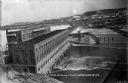
| Date: | 02 28 1915 |
|---|---|
| Description: | Elevated view, looking east, of the power house, lock, and dam on the Wisconsin River. |

| Date: | 1890 |
|---|---|
| Description: | Shows vacant state land, government land, townships, and selected farms, camps, saw mills, etc. in Vilas and Oneida Counties, and part of Iron County. "For... |
| Date: | 1922 |
|---|---|
| Description: | View from shoreline of bridge over the Wisconsin River. In the left lower foreground is a shed, and a rowboat. On the opposite shoreline are farms and fiel... |

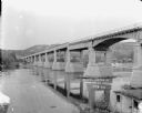
| Date: | |
|---|---|
| Description: | View across water towards a wooden wagon bridge over the Wisconsin River. A farm and tree-covered hills are on the opposite shoreline. |

| Date: | 1838 |
|---|---|
| Description: | This map is a development plat that shows street names, numbered blocks and lots, and small farm lot owners. Included on the right of the map is a large am... |
If you didn't find the material you searched for, our Library Reference Staff can help.
Call our reference desk at 608-264-6535 or email us at: