 Filter: Categories of Wisconsin Historical Images
Filter: Subject of Ferries
Filter: Subject of land use
Filter: Categories of Wisconsin Historical Images
Filter: Subject of Ferries
Filter: Subject of land use
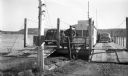
| Date: | 1940 |
|---|---|
| Description: | Colsac Ferry across the Wisconsin River at Merrimac. There is a bridge across the river in the background on the left. |
| Date: | 1969 |
|---|---|
| Description: | The Island's Edge, Williamsburg Bridge, East River. |

| Date: | 1998 |
|---|---|
| Description: | Ile de la Cite, on the Seine River in Paris, France. |
| Date: | 07 13 1915 |
|---|---|
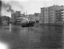
| Description: | Looking south from Wells Street. A boat travels along the Milwaukee River in the foreground. Landmarks left to right: Manufacturers Home Building, First Na... |
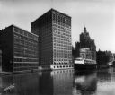
| Date: | |
|---|---|
| Description: | Elevated view of two Goodrich Line passenger ferries docked on the west bank of the Milwaukee River, north of the Clybourn Street bridge. The Pabst buildin... |
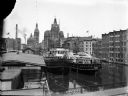
| Date: | |
|---|---|
| Description: | Looking north on the Milwaukee River as the whaleback excursion steamer "Christopher Columbus" is guided by tugboats at about St. Paul Avenue. |

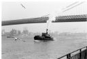
| Date: | 1968 |
|---|---|
| Description: | View of Manhattan from the Staten Island Ferry, with a couple standing in the foreground. The woman is wearing a leopard print coat, and seagulls wheel in ... |

| Date: | 1890 |
|---|---|
| Description: | The "J.C. Ames," a Lake Michigan car ferry, probably in the South Chicago harbor. There is a railroad bridge visible in the background. |
| Date: | 06 05 1955 |
|---|---|
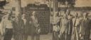
| Description: | Officials gathered to dedicate the Knaggs Ferry historical marker in Oshkosh. The officials included, from left to right, Edward Hamilton, vice-president o... |
| Date: | 06 05 1955 |
|---|---|
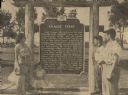
| Description: | Fourth, fifth, and sixth generations of the Knaggs family gathered by the Knaggs Ferry historical marker to honor their family member. Mrs. Walter Dugolens... |

| Date: | 1789 |
|---|---|
| Description: | Map of New York City showing ward boundaries, ferries, streets, roads, swamps, ponds, and rivers. The properties of Lispinard, Byards, Jones, Rutgers, and ... |

| Date: | 1776 |
|---|---|
| Description: | Fairly detailed map of New York City and parts of Long Island. It shows streets, roads, wharves, ferries, ship yards, Fort George and the battery, public b... |

| Date: | 1936 |
|---|---|
| Description: | This colored road map shows automobile roads in Wisconsin as well as portions of Michigan, Iowa, Minnesota, and Illinois. U.S. numbered highways are shown ... |

| Date: | 1936 |
|---|---|
| Description: | This colored road map shows automobile roads in Wisconsin as well as portions of nearby states. Information on the quality and type of any given road (pave... |
If you didn't find the material you searched for, our Library Reference Staff can help.
Call our reference desk at 608-264-6535 or email us at: