 Filter: Categories of Wisconsin Historical Images
Filter: Subject of Field crops
Filter: Subject of rivers
Filter: Categories of Wisconsin Historical Images
Filter: Subject of Field crops
Filter: Subject of rivers
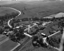
| Date: | 09 10 1947 |
|---|---|
| Description: | Aerial view of the River View Cannery. |
| Date: | |
|---|---|
| Description: | Elevated view of a farmer using a horse-drawn plow in a field near Deer Creek in Spring Valley, Minnesota. Tall rock formation can be seen on the edge of t... |
| Date: | 1920 |
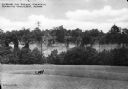
|---|---|
| Description: | A view of a rolling rural landscape, most likely in Sauk County. In the far distance are houses and farm buildings, a church and a larger building, center ... |

| Date: | 1900 |
|---|---|
| Description: | A man leads two horses pulling a McCormick automatic self-rake reaper through a field while another man follows behind. In the background is a river or pon... |

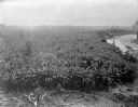
| Date: | 1900 |
|---|---|
| Description: | Three men use a McCormick grain binder in a field overlooking a body of water, probably the Saint John River, in Fredericton, New Brunswick, Canada. Men an... |

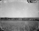
| Date: | |
|---|---|
| Description: | Bundles of a harvested grain stand in a field beyond a body of water. |

| Date: | 1935 |
|---|---|
| Description: | This map shows in different colors virgin timberland, second growth timber, pasture belt, crop-pasture belt, intensive crop-pasture belt, intensive pasture... |

| Date: | 1914 |
|---|---|
| Description: | A hand-colored map of Wisconsin showing the locations of cities and towns, counties, railway lines, the steamship lines in Lake Superior and lake Michigan.... |
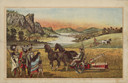
| Date: | 1882 |
|---|---|
| Description: | Back cover of catalog with an illustration of two men using horse-drawn agricultural machinery in fields, while a group of Native American Indians look on.... |
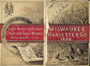
| Date: | 1888 |
|---|---|
| Description: | Front and back cover of catalog, featuring on the front an illustration of birds, mice, and flying insects near a wheat field. The back cover reads: "Manuf... |
| Date: | 1902 |
|---|---|
| Description: | Elevated view of a banana plantation located along a river in Costa Rica. |

| Date: | 1900 |
|---|---|
| Description: | View down hill towards men standing near a horse-drawn carriage on the shoreline of a river. On the other side of the river is a high stone wall with grass... |

| Date: | 1923 |
|---|---|
| Description: | This map includes an explanation that reads: "This chart shows the movement of barley on the Great Lakes, St. Lawrence River, and New York State Barge Cana... |

| Date: | 1923 |
|---|---|
| Description: | This map includes an explanation that reads: "This chart shows the movement of corn on the Great Lakes, St. Lawrence River, and New York State Barge Canal ... |

| Date: | 1923 |
|---|---|
| Description: | This map includes an explanation that reads: "This chart shows the easterly movement of flaxseed on the Great Lakes, St. Lawrence River, and New York State... |

| Date: | 1923 |
|---|---|
| Description: | This map includes an explanation that reads: "This chart shows the movement of grain on the Great Lakes, St. Lawrence River, and New York State Barge Canal... |

| Date: | 1947 |
|---|---|
| Description: | View from hill looking down across fields at the property of Charles Grignon. Grignon Mansion in the background among trees, and beyond is the Fox River. O... |

| Date: | 1770 |
|---|---|
| Description: | The south west sheet of a four sheet map of Virginia, showing the counties, mountains, rivers, court houses, a few cities, and mills. A few Plantations ar... |

| Date: | 1685 |
|---|---|
| Description: | A detailed map of the western hemisphere showing cities, settlements, Native American land, rivers, lakes, mountains, the Great Lakes, and California as an... |
If you didn't find the material you searched for, our Library Reference Staff can help.
Call our reference desk at 608-264-6535 or email us at: