 Filter: Categories of Wisconsin Historical Images
Filter: Subject of Fields (Agriculture)
Filter: Creator Name of Unknown
Filter: Subject of aerial photographs
Filter: Categories of Wisconsin Historical Images
Filter: Subject of Fields (Agriculture)
Filter: Creator Name of Unknown
Filter: Subject of aerial photographs

| Date: | 1908 |
|---|---|
| Description: | Aerial view of Camp Randall Field on the University of Wisconsin-Madison campus. University Heights is in the background. |
| Date: | 1988 |
|---|---|
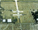
| Description: | Aerial view of the 1988 EAA (Experimental Aviation Association) Convention and Fly-in at Wittman Field. On the ground is the Concorde and a B-1 Bomber. |

| Date: | 1965 |
|---|---|
| Description: | Aerial view of downtown Big Falls and the Little Wolf River. The Little Wolf River is at lower right. |

| Date: | 1905 |
|---|---|
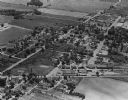
| Description: | Aerial view of town, with several large buildings along railroad tracks in the foreground, and fields and trees in the distance. Pedestrians are walking al... |

| Date: | 1965 |
|---|---|
| Description: | Aerial view of town and Highway 66. |

| Date: | 1930 |
|---|---|
| Description: | Aerial view above Shorewood Hills near Madison, looking northeast. |
| Date: | 1965 |
|---|---|
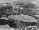
| Description: | Aerial view looking west-northwest over Silver Lake. |
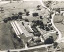
| Date: | 1965 |
|---|---|
| Description: | Aerial view, looking west, with potato warehouses in the foreground and a pallet factory and junkyard behind them at right. |

| Date: | 1960 |
|---|---|
| Description: | Aerial view of the construction of the interstate highway near Mirror Lake, showing only the early stages of the bridge construction. |
| Date: | 1967 |
|---|---|
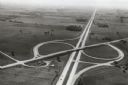
| Description: | Intersection of US Highway 41 and Wisconsin Highway 26 near Oshkosh. |

| Date: | 1979 |
|---|---|
| Description: | Aerial view of Interstate I-90/94 at Camp Douglas, looking northwest. |
| Date: | 1935 |
|---|---|
| Description: | Aerial view of the Northern Wisconsin Hospital for the Insane. |

| Date: | 1910 |
|---|---|
| Description: | Aerial view looking toward Lake Wingra. In the foreground is the Yawkey-Crowley Lumber Yard. The company built it's warehouse at 1542 Monroe Street between... |

| Date: | |
|---|---|
| Description: | Aerial view of Plymouth. Published by McLaughlin Aerial Surveys. |
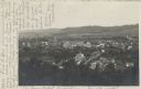
| Date: | 05 22 1906 |
|---|---|
| Description: | Aerial view of the city and rolling hills in the background. A bridge crossing the Trempealeau River is also visible. |
| Date: | |
|---|---|
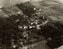
| Description: | Aerial view of the Lakeside Mink Ranch, operated by Robert "Bud" Quinn. Spreading over 15 acres, the Ranch was one of the first operations to breed mink in... |

| Date: | |
|---|---|
| Description: | Aerial view of Vieth's Park subdivision on the north shore of Lake Mendota. |

| Date: | 1910 |
|---|---|
| Description: | Aerial view along river toward Darlington. Caption reads: "Bird's-Eye View, Darlington, Wis." |
If you didn't find the material you searched for, our Library Reference Staff can help.
Call our reference desk at 608-264-6535 or email us at:

