Filter: Categories of Wisconsin Historical Images
Filter: Subject of Fields (Agriculture)
Filter: Creator Name of Unknown
Filter: Subject of land
Filter: Categories of Wisconsin Historical Images
Filter: Subject of Fields (Agriculture)
Filter: Creator Name of Unknown
Filter: Subject of land

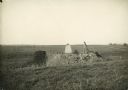
| Date: | 1862 |
|---|---|
| Description: | Camp Randall looking southwest. In April 1861, Governor Alexander Randall asked that the State Agricultural Society fairgrounds be converted into a militar... |
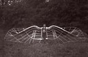
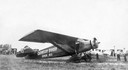
| Date: | 1909 |
|---|---|
| Description: | An unidentified man demonstrates his unsuccessful bird wing-like mechanism, which was part of an experiment in aviation. |
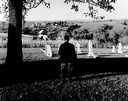
| Date: | |
|---|---|
| Description: | Charles Green, the last survivor of the African American colony at Pleasant Ridge (near Lancaster, WI) looks out over the community graveyard. |
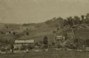
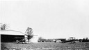
| Date: | 1875 |
|---|---|
| Description: | View from a distance of a farm in a valley owned by Alex(ander?) Smith. There is a wooden fence in the foreground surrounding the farm. |
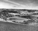
| Date: | 1945 |
|---|---|
| Description: | Elevated view of Trempealeau County, south of Arcadia. |
| Date: | 1932 |
|---|---|
| Description: | In order to undertake a trans-Atlantic flight to Norway, Clyde Allen Lee sought financial support from the local Oshkosh clothing company. The sign painted... |
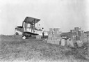
| Date: | 1923 |
|---|---|
| Description: | The hangar and three airplanes (a Canuck and a J-1 Standard) at the airport operated by the Larson Brothers of Larsen, Wisconsin. The field was both the mo... |
| Date: | 1925 |
|---|---|
| Description: | Loading an airplane with calcium arsenate in order to spray for the hemlock looper pest in Peninsula State Park. This is believed to be the first such use ... |
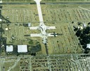
| Date: | 1988 |
|---|---|
| Description: | Aerial view of the 1988 EAA (Experimental Aviation Association) Convention and Fly-in at Wittman Field. On the ground is the Concorde and a B-1 Bomber. |

| Date: | 1874 |
|---|---|
| Description: | Bird's-eye map of Chippewa Falls. |
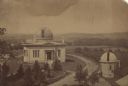
| Date: | 1880 |
|---|---|
| Description: | Elevated view of the University of Wisconsin-Madison Washburn Observatory. Hill, trees and fields are in the background. A man is standing near a small obs... |

| Date: | 1911 |
|---|---|
| Description: | Two farmhouses and the surrounding snowy landscape near Taliesin, the home of Frank Lloyd Wright. |
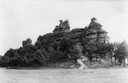
| Date: | 1937 |
|---|---|
| Description: | Castle Rock. Castle Rock is an example of a monadnock or inselberg, a geological formation common in northern and central Wisconsin. |
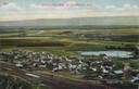
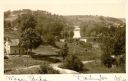
| Date: | |
|---|---|
| Description: | Elevated view of Cochrane and the surrounding landscape. There are houses, railroad tracks, distant fields, a pond and some irrigation canals. Caption read... |
| Date: | 1860 |
|---|---|
| Description: | Elevated view of multiple buildings in Cross Plains from Lutheran Church Hill. Many roads and fences cross the fields. Wooded hills are in the background. ... |
| Date: | 1900 |
|---|---|
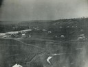
| Description: | Elevated view of wagon bridge in Darlington, with a river on the right, a cow in a field, and a building on the left. |

| Date: | 1910 |
|---|---|
| Description: | Elevated view of the Pecatonica River, which is curving from left to right, making two hairpin turns among fields and trees. Hills are in the distance. |

| Date: | 1884 |
|---|---|
| Description: | View of buildings in Delafield, with two men and a dog standing near a fence in the foreground. |
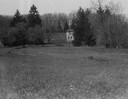
| Date: | |
|---|---|
| Description: | Rock Studio across a field, surrounded by trees. |
If you didn't find the material you searched for, our Library Reference Staff can help.
Call our reference desk at 608-264-6535 or email us at: