 Filter: Categories of Wisconsin Historical Images
Filter: Subject of Fields (Agriculture)
Filter: Creator Name of Unknown
Filter: Subject of landscape
Filter: Categories of Wisconsin Historical Images
Filter: Subject of Fields (Agriculture)
Filter: Creator Name of Unknown
Filter: Subject of landscape

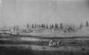
| Date: | 1862 |
|---|---|
| Description: | Camp Randall looking southwest. In April 1861, Governor Alexander Randall asked that the State Agricultural Society fairgrounds be converted into a militar... |
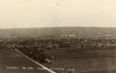
| Date: | 1945 |
|---|---|
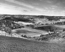
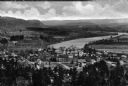
| Description: | Elevated view of Trempealeau County, south of Arcadia. |

| Date: | 1911 |
|---|---|
| Description: | Two farmhouses and the surrounding snowy landscape near Taliesin, the home of Frank Lloyd Wright. |
| Date: | |
|---|---|
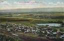
| Description: | Elevated view of Cochrane and the surrounding landscape. There are houses, railroad tracks, distant fields, a pond and some irrigation canals. Caption read... |

| Date: | 1910 |
|---|---|
| Description: | Elevated view of the Pecatonica River, which is curving from left to right, making two hairpin turns among fields and trees. Hills are in the distance. |
| Date: | |
|---|---|
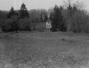
| Description: | Rock Studio across a field, surrounded by trees. |

| Date: | 1905 |
|---|---|
| Description: | View across field and fence downhill towards the town of Fish Creek and the bay. Caption reads: "Greetings from Fish Creek, Wis." |

| Date: | 03 1963 |
|---|---|
| Description: | Panoramic landscape view of the Fey Farm near Dexterville, Wood County. The view shows the farmstead and much of the surrounding acreage and woodlands. T... |
| Date: | 1898 |
|---|---|
| Description: | The site of the encounter between Black Hawk and his followers and General Henry. |
| Date: | |
|---|---|
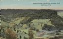
| Description: | Colorized view of Ebner's Coulee. Caption reads: "Ebner's Coulee, taken from Grandad Bluff, La Crosse, Wis." |
| Date: | 1860 |
|---|---|
| Description: | Elevated view of the Roman Catholic community of St. Nazianz. |

| Date: | 1979 |
|---|---|
| Description: | Aerial view of Interstate I-90/94 at Camp Douglas, looking northwest. |

| Date: | 10 1905 |
|---|---|
| Description: | Elevated view from Reservoir Bluff to the east of the town. The bluffs of Iowa can be seen in the distance. |
| Date: | 1930 |
|---|---|
| Description: | Elevated view of the north side of town, from high on the bluff. Caption reads: "'Birdseye' No. End Prairie Du Chien, Wis." |

| Date: | 1920 |
|---|---|
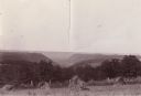
| Description: | Upland prairie farming country with a view of the fields. |
| Date: | |
|---|---|
| Description: | Elevated view of a fertile valley in Twin Falls, Idaho. The Snake River can be seen running through the valley. Geological formations can be seen nearby. |

| Date: | 1910 |
|---|---|
| Description: | A distant view of the Bartlett and Kearsarge Mountains. A field and trees are in the foreground, and a white house is nestled in the forest further up the ... |
| Date: | |
|---|---|
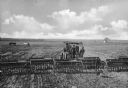
| Description: | Elevated view of two men using agricultural machinery to drill (plant) wheat. "Superior" sign is on the machinery. A boy and a dog stand nearby. A horse an... |
| Date: | |
|---|---|
| Description: | Elevated view of country town showing large. There are wooden buildings alongside the Delaware River which curves through fields and patches of woods in th... |

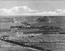
| Date: | 1920 |
|---|---|
| Description: | A vast oil field displays how Oklahoma became the the largest oil-producer in the country. Caption reads: "Oil Fields near Tulsa, Okla." |
If you didn't find the material you searched for, our Library Reference Staff can help.
Call our reference desk at 608-264-6535 or email us at: