Filter: Categories of Wisconsin Historical Images
Filter: Subject of Fields (Agriculture)
Filter: Creator Name of Unknown
Filter: Subject of rivers
Filter: Categories of Wisconsin Historical Images
Filter: Subject of Fields (Agriculture)
Filter: Creator Name of Unknown
Filter: Subject of rivers

| Date: | 1874 |
|---|---|
| Description: | Bird's-eye map of Chippewa Falls. |
| Date: | |
|---|---|
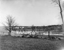
| Description: | View across field towards the railroad bridge, seen with the construction almost completed. A man is standing in the middle of the bridge, and two or three... |

| Date: | 1965 |
|---|---|
| Description: | Aerial view of downtown Big Falls and the Little Wolf River. The Little Wolf River is at lower right. |
| Date: | 1900 |
|---|---|
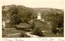
| Description: | Elevated view of wagon bridge in Darlington, with a river on the right, a cow in a field, and a building on the left. |

| Date: | 1910 |
|---|---|
| Description: | Elevated view of the Pecatonica River, which is curving from left to right, making two hairpin turns among fields and trees. Hills are in the distance. |

| Date: | 1898 |
|---|---|
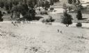
| Description: | View from water tower, showing the grove where Black Hawk's pursuers were supposed to have camped in 1832. The group of men in the foreground are digging f... |

| Date: | 1960 |
|---|---|
| Description: | Aerial view of the construction of the interstate highway near Mirror Lake, showing only the early stages of the bridge construction. |
| Date: | 1880 |
|---|---|
| Description: | Illustration of an elevated view over rooftops looking towards Oshkosh. There are chimneys along the horizon with smoke rising into the sky. A river is alo... |
| Date: | |
|---|---|
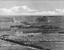
| Description: | Elevated view of a fertile valley in Twin Falls, Idaho. The Snake River can be seen running through the valley. Geological formations can be seen nearby. |
| Date: | |
|---|---|
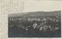
| Description: | Elevated view of country town showing large. There are wooden buildings alongside the Delaware River which curves through fields and patches of woods in th... |

| Date: | 1910 |
|---|---|
| Description: | Elevated view of the First Presbyterian church and two mansions. The Mahoning river and a park is in the foreground, and other parts of the town stretch in... |

| Date: | |
|---|---|
| Description: | Bundles of a harvested grain stand in a field beyond a body of water. |
| Date: | |
|---|---|
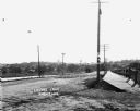
| Description: | View of Lovers Lane, which a dirt road with a sidewalk and bridge on the right. There are power lines in the foreground, and a town in the background. Ther... |

| Date: | |
|---|---|
| Description: | Colorized postcard of the horseshoe curve of railroad tracks. Elevated view of the railroad tracks with train snaking past a farmhouse and a bridge suspend... |
| Date: | 05 22 1906 |
|---|---|
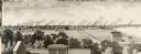
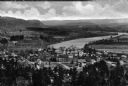
| Description: | Aerial view of the city and rolling hills in the background. A bridge crossing the Trempealeau River is also visible. |
| Date: | |
|---|---|
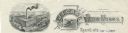
| Description: | Memohead of the J.I. Case Plow Works of Racine, Wisconsin, with an elevated view of the company plant and a smaller scene set on a scroll of a man driving ... |

| Date: | 1899 |
|---|---|
| Description: | Overhead map of the Stanley McCormick's Riven Rock estate in El Montecito, Santa Barbara, California. The map shows the placement of dwellings and fields, ... |
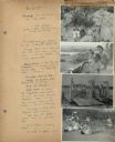
| Date: | 07 22 1941 |
|---|---|
| Description: | Scrapbook page of trip highlights from a bike hosteling trip to Pine Bluff (Dane County), Sauk City (Sauk County), and Okee (Columbia County), sponsored by... |
If you didn't find the material you searched for, our Library Reference Staff can help.
Call our reference desk at 608-264-6535 or email us at: