 Filter: Categories of Wisconsin Historical Images
Filter: Subject of Fields (Agriculture)
Filter: Community of Madison
Filter: Subject of aerial photographs
Filter: Categories of Wisconsin Historical Images
Filter: Subject of Fields (Agriculture)
Filter: Community of Madison
Filter: Subject of aerial photographs

| Date: | 1956 |
|---|---|
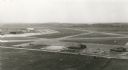
| Description: | Aerial view of the South Park Street interchange. |

| Date: | 1908 |
|---|---|
| Description: | Aerial view of Camp Randall Field on the University of Wisconsin-Madison campus. University Heights is in the background. |

| Date: | 1950 |
|---|---|
| Description: | Aerial view of the Frank Lloyd-Wright-dsigned Unitarian Church under construction and the Veteran's Administration Hospital, also under construction, to th... |

| Date: | 1956 |
|---|---|
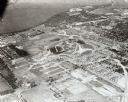
| Description: | Aerial view of the new Madison television facility, WISC-TV (Channel 3), showing the transmitting tower in construction. The location is to the southwest,... |

| Date: | 1956 |
|---|---|
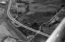
| Description: | Aerial view, looking eastward from a point several miles outside the southwestern limits of Madison in the direction of Verona. Crossing the image diagonal... |

| Date: | 1930 |
|---|---|
| Description: | Aerial view above Shorewood Hills near Madison, looking northeast. |

| Date: | |
|---|---|
| Description: | An aerial view of both Picnic Point and Second Point looking toward the isthmus. Members of the Jackson Family had summer homes at Second Point at this tim... |
| Date: | 1955 |
|---|---|
| Description: | An aerial view at Truax Field showing the Municipal Airport Administration Building. |
| Date: | 09 1958 |
|---|---|
| Description: | Aerial view of University Farms neighborhood near Lake Mendota. |
| Date: | 09 1958 |
|---|---|
| Description: | University Hill Farms from an aerial perspective. |

| Date: | 1910 |
|---|---|
| Description: | Aerial view looking toward Lake Wingra. In the foreground is the Yawkey-Crowley Lumber Yard. The company built it's warehouse at 1542 Monroe Street between... |

| Date: | 02 09 1949 |
|---|---|
| Description: | One of four aerial views of the Edwin Blaney farm and farm buildings surrounded by snow-covered fields. Four miles south of Madison and a mile west of U.S.... |
| Date: | 1958 |
|---|---|
| Description: | Aerial view of Kapec Orchards on Verona Road between McKee and Nesbitt Roads. |

| Date: | |
|---|---|
| Description: | An aerial view of Governor's Island. A cutout of an arrow has been added. |

| Date: | 1955 |
|---|---|
| Description: | Aerial view, looking west from over Hoyt Park toward Midvale Boulevard. |

| Date: | |
|---|---|
| Description: | Aerial view of Vieth's Park subdivision on the north shore of Lake Mendota. |

| Date: | 1960 |
|---|---|
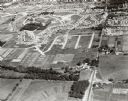
| Description: | Aerial view of rural landscape with suburban construction in foreground. Cottage Grove Road is at left with the newly constructed Acewood Boulevard crossin... |
| Date: | 1979 |
|---|---|
| Description: | Text on reverse reads: "Madison, Wisconsin photographed on infrared film at an altitude of 22 miles from a NASA research aircraft. Red = vegetation Blue ... |

| Date: | 1954 |
|---|---|
| Description: | Aerial view of the construction of Herbert Schenk Elementary School, as well as the surrounding neighborhood. |
If you didn't find the material you searched for, our Library Reference Staff can help.
Call our reference desk at 608-264-6535 or email us at:
