Filter: Categories of Wisconsin Historical Images
Filter: Subject of Fields (Agriculture)
Filter: Community of Madison
Filter: Subject of land use, rural
Filter: Categories of Wisconsin Historical Images
Filter: Subject of Fields (Agriculture)
Filter: Community of Madison
Filter: Subject of land use, rural
| Date: | 03 04 1932 |
|---|---|
| Description: | Piper Brothers farm scene, 4718 Odana Road near Midvale. |
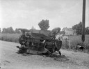
| Date: | 10 20 1931 |
|---|---|
| Description: | Accident scene on Highway 51, rural area. Caption at bottom reads: "High #51 — Looking West — Northwest — October 20, 1931 2:00 P.M." |
| Date: | 05 25 1931 |
|---|---|
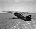
| Description: | Three-quarter view from left rear towards the "Keen-Ship" airplane parked on a field, with Charles F. Keen, pilot. |
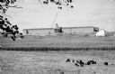
| Date: | 05 23 1931 |
|---|---|
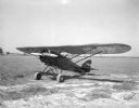
| Description: | Three-quarter view from front left towards an airplane parked in a field, "The Keen Ship," made by Charles F. Keen. |

| Date: | 1956 |
|---|---|
| Description: | Aerial view of the new Madison television facility, WISC-TV (Channel 3), showing the transmitting tower in construction. The location is to the southwest,... |

| Date: | 08 11 1944 |
|---|---|
| Description: | Six Russian representatives of the Soviet government observing a new McCormick-Deering Company Model 50-T hay baler at the Bowman Dairy Farm on Fish Hatche... |
| Date: | |
|---|---|
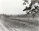
| Description: | View from the western countryside towards Lake Wingra, looking east. In the foreground is a dirt road and fence. |
| Date: | 06 1955 |
|---|---|
| Description: | View towards the Wisconsin State Capitol from the outlying area around Madison. Just beyond the cornfield in the foreground are buildings, one with a sign ... |

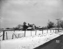
| Date: | 02 09 1949 |
|---|---|
| Description: | One of four aerial views of the Edwin Blaney farm and farm buildings surrounded by snow-covered fields. Four miles south of Madison and a mile west of U.S.... |

| Date: | |
|---|---|
| Description: | You came to know that book by its covered distance, well remembered by the measure of the trudging barefoot mile |
| Date: | 09 15 1964 |
|---|---|
| Description: | The new $3 million Holy Name Seminary, located at 702. S. High Point Road in Madison, is ready for its first class of 205 students. |

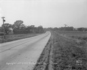
| Date: | 08 2013 |
|---|---|
| Description: | View near Mineral Point Road across grass and Queen Anne's lace and a cornfield towards a line of black locust trees. |

| Date: | 10 2013 |
|---|---|
| Description: | Elevated view of a donkey walking in a field in front of a sign which reads: "Jesus said:... 'Except a man be born again, he cannot see the Kingdom of God'... |

| Date: | |
|---|---|
| Description: | View from parking lot of "Del Wood's Country Store, Cheese, Liquor, Gift Shoppe." Three people are standing on the covered porch near the entrance. Agricul... |

| Date: | 06 30 1895 |
|---|---|
| Description: | A man is standing in the right foreground near a tall plant, perhaps corn. In the center is a square-shaped pond with high banks. A man is in the backgroun... |

| Date: | 1960 |
|---|---|
| Description: | Aerial view of rural landscape with suburban construction in foreground. Cottage Grove Road is at left with the newly constructed Acewood Boulevard crossin... |

| Date: | 1958 |
|---|---|
| Description: | The Schuepbach Farm off East Clayton Road, with a view of the Wisconsin State Capitol in the far distance. |

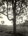
| Date: | |
|---|---|
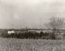
| Description: | View across fence through trees towards fields and farm buildings. |
If you didn't find the material you searched for, our Library Reference Staff can help.
Call our reference desk at 608-264-6535 or email us at: