Filter: Categories of Wisconsin Historical Images
Filter: Subject of Fields (Agriculture)
Filter: Community of Madison
Filter: Subject of roads
Filter: Categories of Wisconsin Historical Images
Filter: Subject of Fields (Agriculture)
Filter: Community of Madison
Filter: Subject of roads

| Date: | 1956 |
|---|---|
| Description: | Aerial view of the South Park Street interchange. |
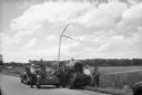
| Date: | 03 04 1932 |
|---|---|
| Description: | Piper Brothers farm scene, 4718 Odana Road near Midvale. |
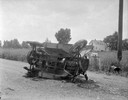
| Date: | 10 20 1931 |
|---|---|
| Description: | Accident scene on Highway 51, rural area. Caption at bottom reads: "High #51 — Looking West — Northwest — October 20, 1931 2:00 P.M." |
| Date: | 07 27 1944 |
|---|---|
| Description: | City of Madison staff demonstrating homemade liquid mosquito sprayer designed by Dr. Bernhard "Dommie" Domogalla, city biochemist. Left to right: LeRoy Joh... |

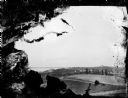
| Date: | 1910 |
|---|---|
| Description: | Aerial view looking toward Lake Wingra. In the foreground is the Yawkey-Crowley Lumber Yard. The company built it's warehouse at 1542 Monroe Street between... |
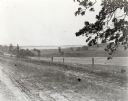
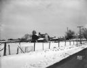
| Date: | |
|---|---|
| Description: | View from the western countryside towards Lake Wingra, looking east. In the foreground is a dirt road and fence. |
| Date: | 1958 |
|---|---|
| Description: | Aerial view of Kapec Orchards on Verona Road between McKee and Nesbitt Roads. |
| Date: | |
|---|---|
| Description: | Slightly elevated view over fields of the University of Wisconsin-Madison, showing Bascom Hall, the Observatory, and King Hall from University Heights. Lak... |

| Date: | 1955 |
|---|---|
| Description: | Aerial view, looking west from over Hoyt Park toward Midvale Boulevard. |
| Date: | 05 1900 |
|---|---|
| Description: | A young girl, Kathleen Carlyle, standing on Linden Drive located on the University of Wisconsin campus. She is wearing a dress and a bonnet, and is standin... |

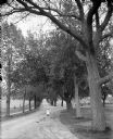
| Date: | 1900 |
|---|---|
| Description: | View down Linden Drive on the University of Wisconsin-Madison campus. Original caption reads, "Linden Drive in the spring time." Trees line both side of th... |

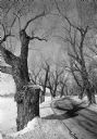
| Date: | |
|---|---|
| Description: | You came to know that book by its covered distance, well remembered by the measure of the trudging barefoot mile |

| Date: | |
|---|---|
| Description: | Slightly elevated view over fields of the University of Wisconsin-Madison, showing, from right, Bascom Hall, the Observatory, and King Hall (1525 Observato... |
| Date: | 1982 |
|---|---|
| Description: | Large specimens of Salix alba line Willow Drive on the University of Wisconsin-Madison campus. Some of the trees date from the 1890s, and many have ... |

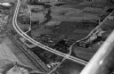
| Date: | 1960 |
|---|---|
| Description: | Aerial view of rural landscape with suburban construction in foreground. Cottage Grove Road is at left with the newly constructed Acewood Boulevard crossin... |

| Date: | |
|---|---|
| Description: | View from roadside, with a tree in the foreground, towards a field with haystacks, and farm buildings in the distance among trees. |

| Date: | |
|---|---|
| Description: | View from road, with the front of an automobile on the right, towards a farm. Cows and pigs are in a pasture, and two silos are next to the barn. |

| Date: | 1928 |
|---|---|
| Description: | Birds-eye view showing Lake Mendota, Lake Monona, Lake Wingra, Lake Waubesa and Lake Kegonsa. Shows the growth of Madison from the Isthmus along the southe... |
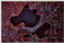
| Date: | 1979 |
|---|---|
| Description: | Text on reverse reads: "Madison, Wisconsin photographed on infrared film at an altitude of 22 miles from a NASA research aircraft. Red = vegetation Blue ... |
If you didn't find the material you searched for, our Library Reference Staff can help.
Call our reference desk at 608-264-6535 or email us at: