Filter: Categories of Wisconsin Historical Images
Filter: Subject of Fields (Agriculture)
Filter: County of Dane
Filter: Subject of land use, rural
Filter: Categories of Wisconsin Historical Images
Filter: Subject of Fields (Agriculture)
Filter: County of Dane
Filter: Subject of land use, rural

| Date: | 1873 |
|---|---|
| Description: | Main Street, with its dirt, ruts, cows (and presumably manure), but wide enough for easy hitching of wagons and teams. |
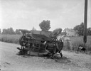
| Date: | 04 15 1934 |
|---|---|
| Description: | Onlookers surveying damage from a fatal two-car collision. The view is looking south on County Trunk Highway M, between Speedway Road and Middleton. In the... |

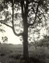
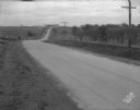
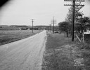
| Date: | 12 01 1962 |
|---|---|
| Description: | A farm road between fields in late sunlight, looking towards Mounds Creek in the vicinity of CTH F. |
| Date: | 03 04 1932 |
|---|---|
| Description: | Piper Brothers farm scene, 4718 Odana Road near Midvale. |
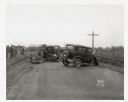
| Date: | 10 20 1931 |
|---|---|
| Description: | Accident scene on Highway 51, rural area. Caption at bottom reads: "High #51 — Looking West — Northwest — October 20, 1931 2:00 P.M." |
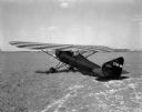
| Date: | 05 25 1931 |
|---|---|
| Description: | Three-quarter view from left rear towards the "Keen-Ship" airplane parked on a field, with Charles F. Keen, pilot. |
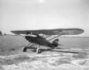
| Date: | 05 23 1931 |
|---|---|
| Description: | Three-quarter view from front left towards an airplane parked in a field, "The Keen Ship," made by Charles F. Keen. |
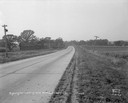
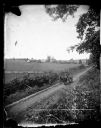
| Date: | 11 08 1928 |
|---|---|
| Description: | Stretch of paved rural highway featuring a proprietary centerline joint, looking towards Mount Horeb from the east. |
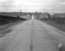
| Date: | 11 08 1928 |
|---|---|
| Description: | Stretch of paved rural highway near Mount Horeb featuring a proprietary centerline joint. |
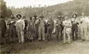
| Date: | 1913 |
|---|---|
| Description: | Group of farm workers, men and women, posing in a field, holding various beverages. One man has his arm over a barrel on a stand in the center. In the back... |
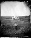
| Date: | |
|---|---|
| Description: | View of the Quammen family farm with a man in the foreground standing in a field. Behind him and across the field is an upright and wing frame house with w... |
| Date: | 1875 |
|---|---|
| Description: | Elevated view of a man driving a horse-drawn wagon along a rural lane with a man walking in front on the left. In the background is a field, fences, farmho... |
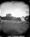
| Date: | 1876 |
|---|---|
| Description: | View of a farmstead with fences, haystacks and a wooden building. A man is in the background on top of McCord Rock, also called Devil's Chimney, Preacher'... |
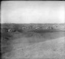
| Date: | 1860 |
|---|---|
| Description: | Elevated view of multiple buildings in Cross Plains from Lutheran Church Hill. Many roads and fences cross the fields. Wooded hills are in the background. ... |
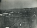
| Date: | 1928 |
|---|---|
| Description: | View from hill of uptown Cross Plains with the Catholic Church (St. Francis Xavier) and farmhouses. |

| Date: | 1956 |
|---|---|
| Description: | Aerial view of the new Madison television facility, WISC-TV (Channel 3), showing the transmitting tower in construction. The location is to the southwest,... |
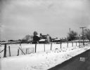
| Date: | 10 11 1949 |
|---|---|
| Description: | Buckeye Road accident scene, looking north near Homburg farm, 3976 County Trunk Highway AB. |
If you didn't find the material you searched for, our Library Reference Staff can help.
Call our reference desk at 608-264-6535 or email us at: