 Filter: Categories of Wisconsin Historical Images
Filter: Subject of Fields (Agriculture)
Filter: County of Dane
Filter: Subject of landscape
Filter: Categories of Wisconsin Historical Images
Filter: Subject of Fields (Agriculture)
Filter: County of Dane
Filter: Subject of landscape

| Date: | 1873 |
|---|---|
| Description: | Main Street, with its dirt, ruts, cows (and presumably manure), but wide enough for easy hitching of wagons and teams. |

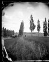
| Date: | 1862 |
|---|---|
| Description: | Camp Randall looking southwest. In April 1861, Governor Alexander Randall asked that the State Agricultural Society fairgrounds be converted into a militar... |
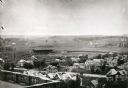
| Date: | 1906 |
|---|---|
| Description: | Elevated view of Camp Randall Field from the top of Bascom Hall, with University Heights in the background. A crowd is in the stands at the stadium, and a ... |

| Date: | 12 01 1962 |
|---|---|
| Description: | A farm road between fields in late sunlight, looking towards Mounds Creek in the vicinity of CTH F. |
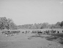
| Date: | 10 10 1945 |
|---|---|
| Description: | Herd of beef cattle in a field near Marshall, Wisconsin. |
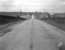
| Date: | 11 08 1928 |
|---|---|
| Description: | Stretch of paved rural highway featuring a proprietary centerline joint, looking towards Mount Horeb from the east. |
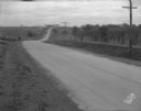
| Date: | 11 08 1928 |
|---|---|
| Description: | Stretch of paved rural highway near Mount Horeb featuring a proprietary centerline joint. |
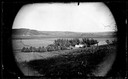
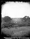
| Date: | 1873 |
|---|---|
| Description: | View across field towards the Amund Rustebakke farm. Twelve haystacks dominate the left and center of the image, and two people are standing on top of the ... |
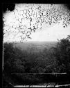
| Date: | |
|---|---|
| Description: | View over trees towards a farm and fields, possibly those of G. Tollefson. |
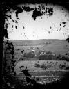
| Date: | 1873 |
|---|---|
| Description: | View of several farms, including Burton's, Fitlen's and Rustebakke's. Field arrangements and fencing patterns are evident. A man is walking along the bott... |
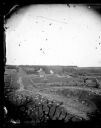
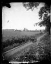
| Date: | 1873 |
|---|---|
| Description: | View down a rocky rural lane near West Blue Mounds. Zigzag stake and rider split-rail fencing enclose a farmstead, which includes a barn, a frame house, ha... |
| Date: | 1874 |
|---|---|
| Description: | View down hill towards two men in the foreground standing on top of a stone fence looking out onto fields where two or three men are working with two wagon... |
| Date: | |
|---|---|
| Description: | View down a poplar-lined lane with fields and fences on the right. A man and child are sitting in the lane in a horse-drawn wagon with a team of two horses... |
| Date: | 1875 |
|---|---|
| Description: | Elevated view of a man driving a horse-drawn wagon along a rural lane with a man walking in front on the left. In the background is a field, fences, farmho... |

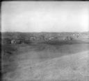
| Date: | 1874 |
|---|---|
| Description: | Distant view of the town from a hill with houses, garden plots, businesses and churches. |

| Date: | 05 10 1928 |
|---|---|
| Description: | The Lutheran Church and buildings, seen from Lutheran Church Hill. |
| Date: | 1928 |
|---|---|
| Description: | View from hill of uptown Cross Plains with the Catholic Church (St. Francis Xavier) and farmhouses. |
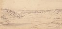
| Date: | 1852 |
|---|---|
| Description: | Pencil drawing of Black Earth Valley. Gentle lightly tree-covered hills frame the center grassy valley. Two farmhouses are sitting at the base of hills on ... |

| Date: | 06 16 1949 |
|---|---|
| Description: | Freda Winterble property, 901 University Bay Drive, looking north toward Lake Mendota, showing trees on right side of road and house on the left, 928 Unive... |

| Date: | 1909 |
|---|---|
| Description: | View from Sunset Point in Owen Park, which is now a part of Hoyt Park. Lake Mendota is in the distance. |
If you didn't find the material you searched for, our Library Reference Staff can help.
Call our reference desk at 608-264-6535 or email us at: