Filter: Categories of Wisconsin Historical Images
Filter: Subject of Fields (Agriculture)
Filter: Subject of aerial photographs
Filter: Categories of Wisconsin Historical Images
Filter: Subject of Fields (Agriculture)
Filter: Subject of aerial photographs

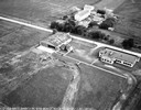
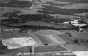
| Date: | 1958 |
|---|---|
| Description: | Aerial view of contour strip farming with the Obert Olstad farm in foreground. The Carl Backum farm is in the background. |

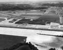
| Date: | 1956 |
|---|---|
| Description: | Aerial view of the South Park Street interchange. |

| Date: | 1908 |
|---|---|
| Description: | Aerial view of Camp Randall Field on the University of Wisconsin-Madison campus. University Heights is in the background. |

| Date: | 01 1934 |
|---|---|
| Description: | Aerial view of New Butler, in Waukesha County. |

| Date: | 1950 |
|---|---|
| Description: | Aerial view of the Frank Lloyd-Wright-dsigned Unitarian Church under construction and the Veteran's Administration Hospital, also under construction, to th... |
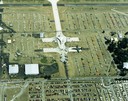
| Date: | 1988 |
|---|---|
| Description: | Aerial view of the 1988 EAA (Experimental Aviation Association) Convention and Fly-in at Wittman Field. On the ground is the Concorde and a B-1 Bomber. |
| Date: | |
|---|---|
| Description: | The airfield of the Hamilton Aero Manufacturing Company which became the site of Milwaukee County Airport in 1926. It was established by Thomas Hamilton, a... |

| Date: | 06 1962 |
|---|---|
| Description: | Distant view of U.S helicopters over the Delta Region of South Vietnam taken by Dickey Chapelle, a freelance photographer from Milwaukee. |
| Date: | 1947 |
|---|---|
| Description: | Aerial view of International Harvester's Evansville Works factory complex. |
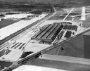
| Date: | 1947 |
|---|---|
| Description: | Aerial view of International Harvester's Evansville Works factory complex. The Evansville Works produced refrigerators, freezers and air conditioners. |
| Date: | 1947 |
|---|---|
| Description: | Aerial view of Lake Seven, surrounded by trees. Agricultural fields fill the foreground. Another lake is in the upper right. Caption reads: "Lake Seven Ade... |

| Date: | 1965 |
|---|---|
| Description: | Aerial view of downtown Big Falls and the Little Wolf River. The Little Wolf River is at lower right. |

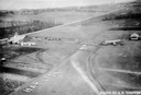
| Date: | 1905 |
|---|---|
| Description: | Aerial view of town, with several large buildings along railroad tracks in the foreground, and fields and trees in the distance. Pedestrians are walking al... |

| Date: | 1965 |
|---|---|
| Description: | Aerial view of town and Highway 66. |

| Date: | 1956 |
|---|---|
| Description: | Aerial view of the new Madison television facility, WISC-TV (Channel 3), showing the transmitting tower in construction. The location is to the southwest,... |
If you didn't find the material you searched for, our Library Reference Staff can help.
Call our reference desk at 608-264-6535 or email us at: