 Filter: Categories of Wisconsin Historical Images
Filter: Subject of Fields (Agriculture)
Filter: Subject of aerial photographs
Filter: Categories of Wisconsin Historical Images
Filter: Subject of Fields (Agriculture)
Filter: Subject of aerial photographs

| Date: | 1962 |
|---|---|
| Description: | Aerial view of four U.S. Marine helicopters banking over an expanse of rice paddies in Vietnam. Fluffy white clouds fill the sky. |
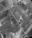
| Date: | 05 1948 |
|---|---|
| Description: | "This shows where Cty Trk P & Hochheim Rd intersect. A small creek cuts through the Wm Kemp Farm." |
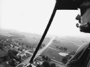
| Date: | 09 1996 |
|---|---|
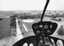
| Description: | "When Pioneer Days was celebrated, visitors were given the chance to view the community from a helicopter." |

| Date: | 09 1996 |
|---|---|
| Description: | "Theresa's Bonduel & Wisconsin Streets from the air." |
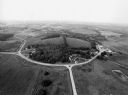
| Date: | 09 1996 |
|---|---|
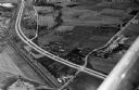
| Description: | "As you look north, North Pole Road intersects DD. At the right is Theresa Station." |
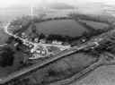
| Date: | 09 1996 |
|---|---|
| Description: | "This is Theresa Station. Note the Rock River and Soo Line Railroad track." |
| Date: | 09 1996 |
|---|---|
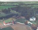
| Description: | "As we approach Firemen's Park, we are at the end of our ride." |
| Date: | |
|---|---|
| Description: | Hand-tinted aerial photograph of the Apps Farm in the Wild Rose vicinity. |

| Date: | 1930 |
|---|---|
| Description: | Aerial view, looking northeast, across Mud Lake with North Bay in the background, showing cultivated fields and wooded land. |

| Date: | 1930 |
|---|---|
| Description: | Aerial view of the northern tip of the Door Peninsula, looking north. Europe Lake is in the center, with Europe Bay to the right. Plum Island and Washingto... |

| Date: | 1930 |
|---|---|
| Description: | Aerial view looking northeast, with Rowley's Bay in the foreground. Europe Lake is to the left, with Europe Bay and Newport Bay separated by a narrow peni... |

| Date: | 1930 |
|---|---|
| Description: | Aerial view over northern Door County, looking northeast across Europe Lake and Europe Bay toward Plum and Washington Islands. Farm fields and orchards con... |

| Date: | 1930 |
|---|---|
| Description: | Aerial view, looking north, across the beach and pier on Europe Bay to Europe Lake and beyond to Washington Island. The land south (to the right) of Europe... |

| Date: | 1949 |
|---|---|
| Description: | Aerial view of factory buildings and grounds at International Harvester's Louisville Works. Roads, fields and trees surround the factory. In the foreground... |
| Date: | 1958 |
|---|---|
| Description: | Aerial view of Kapec Orchards on Verona Road between McKee and Nesbitt Roads. |
| Date: | 1967 |
|---|---|
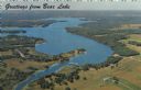
| Description: | Aerial view of Bear Lake, with surrounding forests and farms. Caption reads: "Greetings from Bear Lake." |

| Date: | |
|---|---|
| Description: | An aerial view of Governor's Island. A cutout of an arrow has been added. |

| Date: | 1956 |
|---|---|
| Description: | Aerial view of residential homes, farmland and streets. |
If you didn't find the material you searched for, our Library Reference Staff can help.
Call our reference desk at 608-264-6535 or email us at:

